Kanan, Osaka
Kanan 河南町 | |
|---|---|
 Kanan town office | |
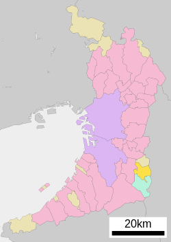
 Location of Kanan in Osaka Prefecture | |
| Coordinates: 34°29′N 135°38′E / 34.483°N 135.633°E | |
| Country | Japan |
| Region | Kansai Kinki |
| Prefecture | Osaka |
| District | Minamikawachi |
| Government | |
| • Mayor | Shōgo Morita |
| Area | |
• Total | 25.26 km2 (9.75 sq mi) |
| Population (January 1, 2022) | |
• Total | 15,429 |
| • Density | 610/km2 (1,600/sq mi) |
| Time zone | UTC+09:00 (JST) |
| Website | Official website |
| Symbols | |
| Flower | Lilium |
| Tree | Sakura |
Kanan (河南町, Kanan-chō) is a town located in Minamikawachi District, Osaka Prefecture, Japan. As of 1 January 2022, the town had an estimated population of 15,429 and a population density of 610 persons per km2. The total area of the town is 25.26 square kilometres (9.75 sq mi).
Geography
Kanan is located in the southeastern part of Osaka Prefecture on the west side of Kongō Range and Katsuragi Mountains which separate Osaka from Nara Prefecture. It is approximately 25 kilometers from central Osaka City. The town is roughly square, measuring 7.5 kilometers east-to-west by 6.7 kilometers north-to-south. The landscape is hilly or mountainous, with about a third of the town area within the borders of Kongō-Ikoma-Kisen Quasi-National Park.[1]
Neighboring municipalities
Nara Prefecture
Osaka Prefecture
Climate
Kanan has a Humid subtropical climate (Köppen Cfa) characterized by warm summers and cool winters with light to no snowfall.
Demographics
Per Japanese census data,[2] the population of Kanan has increased steadily since the 1970s.
| Year | Pop. | ±% |
|---|---|---|
| 1920 | 7,127 | — |
| 1930 | 7,193 | +0.9% |
| 1940 | 7,195 | +0.0% |
| 1950 | 9,424 | +31.0% |
| 1960 | 8,839 | −6.2% |
| 1970 | 8,941 | +1.2% |
| 1980 | 13,967 | +56.2% |
| 1990 | 14,588 | +4.4% |
| 2000 | 17,341 | +18.9% |
| 2010 | 17,032 | −1.8% |
History
The area of the modern town of Kanan was within ancient Kawachi Province. The area has many kofun burial mounds and ancient Buddhist temples. The villages of Ishikawa, Shiraki, Kochi, and Nakamura were established within Ishikawa District with the creation of the modern municipalities system on April 1, 1889. On April 1, 1896 the area became part of Minamikawachi District, Osaka. The four villages merged on September 3, 1956 to form the town of Kanan.
Government
Kanan has a mayor-council form of government with a directly elected mayor and a unicameral city council of 12 members. Kanan collectively with the cities of Tondabayashi and Ōsakasayama, and other municipalities of Minamikawachi District contributes two members to the Osaka Prefectural Assembly. In terms of national politics, the city is part of Osaka 15th district of the lower house of the Diet of Japan.
Economy
Kanan was traditionally dependent on agriculture (eggplants, cucumbers) and forestry, with forests occupying half the town area. Manufacturing is centered around pulp and paper and paper-manufactured goods.[1]
Education
- University
- Middle school
- Kanan Town Junior High School
- Elementary schools
- Kanan Town Chikatsu-Asaka Elementary School
- Kanan Town Kanan Sakura Elementary School
Transportation
Railway
Kanan does not have any passenger rail service. The nearest station is Tondabayashi Station on the Kintetsu Nagano Line.
Highway
Local attractions
- Hirokawa-dera, Buddhist temple with grave of Saigyō
- Ichisuka Kofun Cluster, National Historic Site
- Kanayama Kofun, National Historic Site
Notable people from Kanan
- Naokazu Takemoto, politician
Notes
- ^ a b 町の概要 [Town Summary]. Kanan's official website (in Japanese). Retrieved February 1, 2022.
- ^ Kanan population statistics
External links
 Media related to Kanan, Osaka at Wikimedia Commons
- Official website
 (in Japanese)


