Kagamino
Kagamino 鏡野町 | |
|---|---|
 Okutsu Onsen in Kagamino | |
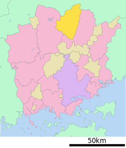
 Location of Kagamino in Okayama Prefecture | |
 | |
| Coordinates: 35°05′31″N 133°55′59″E / 35.09194°N 133.93306°E | |
| Country | Japan |
| Region | Chūgoku San'yō |
| Prefecture | Okayama |
| District | Tomata |
| Area | |
• Total | 419.68 km2 (162.04 sq mi) |
| Population (January 31, 2023) | |
• Total | 12,425 |
| • Density | 30/km2 (77/sq mi) |
| Time zone | UTC+09:00 (JST) |
| City hall address | 660 Takeda, Kagamino-cho, Tomata-gun, Okayama-ken 708-0392 |
| Website | Official website |
| Symbols | |
| Bird | Crested kingfisher |
| Butterfly | Byasa alcinous, Luehdorfia japonica |
| Flower | Gentiana scabra, Sakura |
| Tree | Fagaceae |

Kagamino (鏡野町, Kagamino-chō) is a town located in Tomata District, Okayama Prefecture, Japan. As of 31 January 2023, the town had an estimated population of 12,425 in 5633 households and a population density of 30 persons per km2.[1] The total area of the town is 419.68 square kilometres (162.04 sq mi).
Geography
Kagamino is located in north-central Okayama Prefecture. The Chugoku Mountains form its northern border with Tottori prefecture, with peaks of 1000 meters or more. The southern part of the town is located at the western edge of the Tsuyama Basin, and the Yoshii River flows through the center of the town from north to south.
Neighboring municipalities
Okayama Prefecture
Tottori Prefecture
Climate
Kagamino has a Humid subtropical climate (Köppen Cfa) characterized by warm summers and cool winters with heavy snowfall. The average annual temperature in Kagamino is 13.4 °C. The average annual rainfall is 1501 mm with September as the wettest month. The temperatures are highest on average in January, at around 25.3 °C, and lowest in January, at around 1.7 °C.[2]
Demography
Per Japanese census data,[3] the population of Kagamino has been declining steadily since the 1950s.
| Year | Pop. | ±% |
|---|---|---|
| 1920 | 21,463 | — |
| 1930 | 21,925 | +2.2% |
| 1940 | 20,984 | −4.3% |
| 1950 | 26,126 | +24.5% |
| 1960 | 23,836 | −8.8% |
| 1970 | 18,280 | −23.3% |
| 1980 | 17,493 | −4.3% |
| 1990 | 16,500 | −5.7% |
| 2000 | 15,091 | −8.5% |
| 2010 | 13,575 | −10.0% |
History
The area of Kagamino was part of ancient Mimasaka Province.The town of Kagamino was established by the merger of the villages of Yoshino, Ono, Oda, Nakatani, Kagami-Minami and Kagami-kita on November 10, 1952.
On March 1, 2005, Kagamino absorbed the town of Okutsu, and the villages of Kamisaibara and Tomi, from the Tomata District.
Government
Kagamino has a mayor-council form of government with a directly elected mayor and a unicameral town council of 14 members. Kagamino, collectively with the city of Tsuyama and the towns of Nagi and Shōō, contributes four members to the Okayama Prefectural Assembly. In terms of national politics, the town is part of the Okayama 3rd district of the lower house of the Diet of Japan.
Economy
The main industry in the area is agriculture and forestry. The Yamada Bee Farm Corporation, a noted honey producer, is headquartered in Kagamino.
Education
Kagamino has eight public elementary schools and one public junior high school operated by the town government. The town does not have a high school.
Transportation
Railway
Kagamino does not have any passenger rail service. The nearest train station is Innoshō Station on the JR West Kishin Line in the neighboring Tsuyama.
Highways
Sister cities
Kagamino is twinned with:
Local attractions
- Okutsu Onsen, hot spring resort
References
- ^ "Kagamino town official statistics" (in Japanese). Japan.
- ^ Kagamino climate data
- ^ Kagamino population statistics
- ^ "Association Suisse des Communes et Régions d'Europe". L'Association suisse pour le Conseil des Communes et Régions d'Europe (ASCCRE) (in French). Archived from the original on 2012-07-24. Retrieved 2013-07-20.
External links
 Media related to Kagamino, Okayama at Wikimedia Commons
- Kagamino official website (in Japanese)


