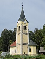
Jama, Kranj
Jama | |
|---|---|
 | |
| Coordinates: 46°11′49.55″N 14°23′59.42″E / 46.1970972°N 14.3998389°E | |
| Country | |
| Traditional region | Upper Carniola |
| Statistical region | Upper Carniola |
| Municipality | Kranj |
| Area | |
• Total | 1.19 km2 (0.46 sq mi) |
| Elevation | 365.2 m (1,198.2 ft) |
| Population (2002) | |
• Total | 202 |
| [1] | |
Jama (pronounced [ˈjaːma]) is a village on the right bank of the Sava River in the Municipality of Kranj in the Upper Carniola region of Slovenia.[2]
Geography
Jama stands above Lake Trboje—the reservoir of the Mavčiče Hydroelectric Plant,[3] which was created in 1986—and the now-submerged Zarica Gorge. The gorge is composed of conglomerate rock, which was used to make millstones.[4] A cave known as Ulrich's Grotto (Slovene: Urhov kevder) lies below the village in the former gorge. The cave is 8 meters (26 ft) long.[5]
Name
Jama was attested in historical sources as Luͦg in 1291, Lug in 1383, Ernluͤg in 1392, and Lueg in 1497, among other variations.[6] The historical German name (cf. Old High German luog 'cave, den') and the modern Slovene name Jama (literally, 'cave') refer to the local geography.[7]
Church

The village church is dedicated to Saint Leonard.[8]
References
- ^ Statistical Office of the Republic of Slovenia
- ^ Kranj municipal site
- ^ "Naselja: Jama". Geopedia.si. Geodetski inštitut Slovenije; Synergise, d. o. o. May 2007. Retrieved 22 August 2013.
- ^ Savnik, Roman (1968). Krajevni leksikon Slovenije, vol. 1. Ljubljana: Državna založba Slovenije. p. 158.
- ^ "Urhov kevder". eKataster jam. Društvo za raziskovanje jam Ljubljana. Retrieved September 25, 2022.
- ^ "Jama". Slovenska historična topografija. ZRC SAZU Zgodovinski inštitut Milka Kosa. Retrieved September 25, 2022.
- ^ Snoj, Marko (2009). Etimološki slovar slovenskih zemljepisnih imen. Ljubljana: Modrijan. p. 173.
- ^ Družina RC Church journal site
External links
 Media related to Jama at Wikimedia Commons
- Jama on Geopedia


