Goshainganj
Goshainganj Gosainganj | |
|---|---|
Town | |
| Coordinates: 26°34′12″N 82°22′48″E / 26.570025°N 82.380130°E | |
| Country | |
| State | Uttar Pradesh |
| District | Ayodhya |
| Founded by | Mahant Iccha Goshain and Rai Ahankaari Singh |
| Elevation | 97 m (318 ft) |
| Population (2011)[1] | |
• Total | 12,931 |
| Language | |
| • Official | Hindi[2] |
| • Additional official | Urdu[2] |
| • Regional | Awadhi |
| Time zone | UTC+5:30 (IST) |
| PIN | 224141 |
| Telephone code | 05278 |
| Vehicle registration | UP-42 |
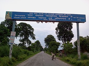
Goshainganj, also known as Gosainganj, is a town and nagar panchayat in the Ayodhya district of the Indian state of Uttar Pradesh.[1][3] Located 32 km from the district headquarters Ayodhya, Goshainganj has one of the oldest markets of the district.
History
A local Baruwar Taluqdar named Rai Ahankaari Singh (Ahankari Rae), gave the glebe land for the current market to a saint named Mahant Inccha Gosai, on whose name, the market and later the town came to be known as Gosainganj. While Gosaiganj Katara bazaar was established by the wife of Madho Singh Barwar.[4][better source needed]
Geography
Goshainganj is located at 26°35′N 82°23′E / 26.58°N 82.38°E.[5] It has an average elevation of 97m.
Demographics
As of 2011 Indian Census, Goshainganj nagar panchayat had a total population of 12,931, of which 6,702 were males and 6,229 were females. Population within the age group of 0 to 6 years was 1,585. The total number of literates in Goshainganj was 9,512, which constituted 73.6% of the population with male literacy of 77.6% and female literacy of 69.2%. The effective literacy rate of 7+ population of Goshainganj was 83.8%, of which male literacy rate was 88.6% and female literacy rate was 78.7%. The Scheduled Caste population was 1,187. Goshainganj had 2121 households in 2011.[1]
Governance and politics
Goshainganj is a part of Goshainganj Vidhan Sabha constituency and Ambedkar Nagar Lok Sabha constituency.[6]
There is a police station in Goshainganj.[7]
Transport
Roadways

Goshainganj is situated along Nawab Yusuf Road (Ayodhya to Jaunpur road) and is well connected to other towns and cities.
Railways

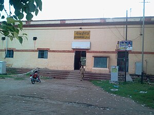
Goshainganj railway station is the nearest railway station situated within the town.
Air
Ayodhya Airport is the nearest airport in Ayodhya, Uttar Pradesh.[8]
Neighbouring cities, towns and markets
See also
References
- ^ a b c "Census of India: Goshainganj". www.censusindia.gov.in. Retrieved 22 February 2021.
- ^ a b "52nd REPORT OF THE COMMISSIONER FOR LINGUISTIC MINORITIES IN INDIA" (PDF). nclm.nic.in. Ministry of Minority Affairs. Archived from the original (PDF) on 25 May 2017. Retrieved 11 October 2020.
- ^ "Municipalities | District Ayodhya - Government of Uttar Pradesh | India". Retrieved 25 February 2021.
- ^ Benett, William Charles (1877). Gazetteer of the province of Oudh. Vol. I, A to G. Cornell University Library. Lucknow: Printed at the Oudh Government Press.
see Ahankaari pur
- ^ "Maps, Weather, and Airports for Gosainganj, India". www.fallingrain.com.
- ^ "Ambedkar Nagar MP (Lok Sabha) Election Results 2019 Live: Candidate List, Constituency Map, Winner & Runner Up". One India. Retrieved 22 February 2021.
- ^ "Police | District Ayodhya - Government of Uttar Pradesh | India". ayodhya.nic.in. Retrieved 22 February 2021.
- ^ Tyagi, Harshita (24 November 2020). "UP Cabinet clears proposal to rename Ayodhya Airport as Maryada Purushottam Sri Ram Airport". Times Now. Retrieved 22 February 2021.

