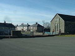
Garndolbenmaen
| Garndolbenmaen | |
|---|---|
 Garndolbenmaen village centre | |
Location within Gwynedd | |
| Population | 365 (2011) |
| OS grid reference | SH497441 |
| Community | |
| Principal area | |
| Country | Wales |
| Sovereign state | United Kingdom |
| Post town | GARNDOLBENMAEN |
| Postcode district | LL51 |
| Dialling code | 01766 |
| Police | North Wales |
| Fire | North Wales |
| Ambulance | Welsh |
| UK Parliament | |
| Senedd Cymru – Welsh Parliament | |
Garndolbenmaen (nicknamed Garn) is a village in the county of Gwynedd, Wales. It lies near the A487, approximately 6 miles (10 km) north west of Porthmadog, in the community of Dolbenmaen, which has a population of 1,300.[1] The closest villages are Dolbenmaen and Bryncir. The Papur Bro, the local Welsh language paper, is called Y Ffynnon (The Source/Spring). The village itself has a population of around 300.[2]
In 1856-7 Evan Jones of Garndolbenmaen built the Ynys-y-Pandy Mill on the nearby Gorseddau Junction and Portmadoc Railway.[3]
Approximately 50 pupils attend Ysgol Gynradd Garndolbenmaen,[4] many pupils travel from nearby villages including Pant Glas, Bryncir, Cwm Pennant and Golan. The number of pupils attending the school has remained consistent over the past 20 years.
Many of the old cottages in Garndolbenmaen have been turned into holiday homes.
Blaen y Cae recording studios are located in the village, where Pep Le Pew's album, Un tro yn y Gorllewin and the last album by Gwyneth Glyn, Wyneb Dros Dro, were recorded.
The magazine Narrow Gauge and Industrial Railway Modelling Review is published in Garndolbenmaen
Climate
Garndolbenmaen has an oceanic climate (Köppen: Cfb).
| Climate data for Cwmystradllyn (204 m or 669 ft elevation, averages 1981–2010) | |||||||||||||
|---|---|---|---|---|---|---|---|---|---|---|---|---|---|
| Month | Jan | Feb | Mar | Apr | May | Jun | Jul | Aug | Sep | Oct | Nov | Dec | Year |
| Mean daily maximum °C (°F) | 6.8 (44.2) |
7.1 (44.8) |
8.9 (48.0) |
11.3 (52.3) |
14.5 (58.1) |
16.8 (62.2) |
18.4 (65.1) |
18.7 (65.7) |
16.0 (60.8) |
13.1 (55.6) |
9.9 (49.8) |
7.6 (45.7) |
12.4 (54.3) |
| Mean daily minimum °C (°F) | 2.3 (36.1) |
1.8 (35.2) |
3.0 (37.4) |
4.2 (39.6) |
7.3 (45.1) |
9.7 (49.5) |
11.9 (53.4) |
11.8 (53.2) |
9.4 (48.9) |
7.1 (44.8) |
4.4 (39.9) |
2.4 (36.3) |
6.3 (43.3) |
| Average rainfall mm (inches) | 181.9 (7.16) |
135.9 (5.35) |
158.8 (6.25) |
121.9 (4.80) |
104.7 (4.12) |
127.5 (5.02) |
143.2 (5.64) |
159.2 (6.27) |
165.3 (6.51) |
220.0 (8.66) |
218.1 (8.59) |
207.9 (8.19) |
1,944.5 (76.56) |
| Average rainy days (≥ 1.0 mm) | 18.7 | 15.8 | 17.0 | 14.7 | 13.2 | 13.1 | 13.8 | 16.0 | 15.4 | 18.3 | 20.0 | 18.9 | 194.9 |
| Mean monthly sunshine hours | 41.4 | 64.3 | 97.5 | 157.3 | 179.6 | 162.0 | 159.8 | 147.0 | 106.8 | 80.7 | 49.8 | 38.5 | 1,284.6 |
| Source: metoffice.gov.uk[5] | |||||||||||||
References
- ^ "Office for National Statistics : Neighbourhood statistics : Census 2001 : Gwynedd". Archived from the original on 22 September 2010. Retrieved 10 August 2009.
- ^ UK Census (2011). "Local Area Report – Garndolbenmaen population (W00000337)". Nomis. Office for National Statistics. Retrieved 9 July 2021.
- ^ "YNYS-Y-PANDY SLATE MILL, CWMYSTRADLLYN;YNYSYPANDY;PONT-Y-PANDY". Royal Commission on the Ancient and Historical Monuments of Wales. The Royal Commission on the Ancient and Historical Monuments of Wales. December 2011. Retrieved 24 June 2020.
- ^ "School Inspection Report" (PDF). ESTYN. 2004.
- ^ "Climate Normals 1981–2010". Met Office. Retrieved 24 February 2021.


