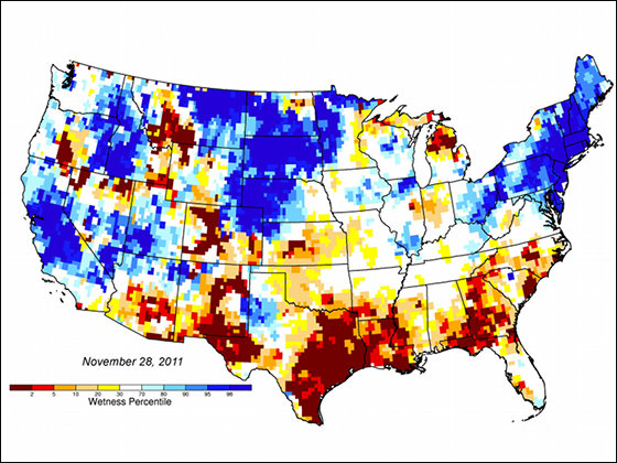
File:USA Groundwater and Soil moisture Drought Map.jpg
USA_Groundwater_and_Soil_moisture_Drought_Map.jpg (560 × 420 pixels, file size: 189 KB, MIME type: image/jpeg)
File history
Click on a date/time to view the file as it appeared at that time.
| Date/Time | Thumbnail | Dimensions | User | Comment | |
|---|---|---|---|---|---|
| current | 22:07, 8 May 2017 |  | 560 × 420 (189 KB) | Bonil009 | User created page with UploadWizard |
File usage
The following 66 pages use this file:
- Wildfire
- User talk:Abyssal
- User talk:AfroThundr3007730/Newsletters/Archive 1
- User talk:Ancheta Wis/Archive 6
- User talk:Andrewa/Archive 14
- User talk:Armanaziz/Archive05
- User talk:Ask123
- User talk:Auric/Archive 15
- User talk:Avicenno
- User talk:Bahb the Illuminated
- User talk:Balablitz/Archive 20
- User talk:BusterD/Archive 15
- User talk:Cactus.man/Archive 15
- User talk:Charlesdrakew/Archives/2018/August
- User talk:Chouette254
- User talk:Cplakidas/Archive 22
- User talk:DavidCane/Archives/Archive 11
- User talk:Ddstretch/Archives/2018/July
- User talk:Dunarc
- User talk:Eruditescholar/2018a
- User talk:Espilio
- User talk:Evad37/Archive 7
- User talk:Finnusertop/Archive/2018
- User talk:Greatedits1/Archive 1
- User talk:Grey Wanderer/Archive 8
- User talk:Hawkeye7/Archive 2018
- User talk:Iazyges/Archives/2018/July
- User talk:Javert2113/Archive 2
- User talk:Keith D/Archive 66
- User talk:Kpgjhpjm/Archive 3
- User talk:L3X1/Archive 6
- User talk:LightandDark2000/Archive 3
- User talk:Master of Time/Archive 4
- User talk:Mercurywoodrose/Archive13
- User talk:Nerd1a4i/Archive 3
- User talk:Nick Moyes/Archive 11
- User talk:Nigos/Archive 3
- User talk:Nolan Perry/Archive 2
- User talk:Northamerica1000/Archive 84
- User talk:OdysseusTroy
- User talk:OhanaUnited/Archive 25
- User talk:Paulmcdonald/Archives/2022/February
- User talk:Pbsouthwood/Archive 10
- User talk:PratyushSinha101/Archive 3
- User talk:RL0919/Archive 2018
- User talk:Railfan01
- User talk:Redolta/Archives 2018-2021
- User talk:Robertgombos/Archive 5
- User talk:SMcCandlish/Archive 140
- User talk:Samee/Archives/2018/July
- User talk:Serenesage
- User talk:Simon Burchell/Archive 19
- User talk:SirGents
- User talk:Slambo/Archives/2018/July
- User talk:Teblick/Archive 4
- User talk:The Grid/Archive 7
- User talk:Tisquesusa/Archive 5
- User talk:Trinitrobrick/Archive 1
- User talk:Vermont/Archive 9
- User talk:Vishal14k
- User talk:Waggers/Archive 26
- User talk:WikiWikiWayne/Archive 40
- User talk:Wumbolo/Archive 2
- User talk:Ww2censor/Archive32
- User talk:Tom
- Wikipedia:WikiProject Portals/Newsletter archive
Global file usage
The following other wikis use this file:
- Usage on cs.wikipedia.org
- Usage on zh.wikipedia.org


