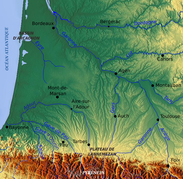
File:Topographic map of Garonne and Adour.svg

Size of this PNG preview of this SVG file: 614 × 600 pixels. Other resolutions: 246 × 240 pixels | 491 × 480 pixels | 786 × 768 pixels | 1,049 × 1,024 pixels | 2,097 × 2,048 pixels | 642 × 627 pixels.
Original file (SVG file, nominally 642 × 627 pixels, file size: 2.9 MB)
File history
Click on a date/time to view the file as it appeared at that time.
| Date/Time | Thumbnail | Dimensions | User | Comment | |
|---|---|---|---|---|---|
| current | 12:36, 13 March 2010 |  | 642 × 627 (2.9 MB) | Pethrus | {{Information |Description={{en|Topographic map of the South-West of France with main rivers and cities}}{{fr|Carte topographique du Sud-Ouest de la France avec rivières et villes principales}} |Source=[[:Image:Topographic map of South-West France with m |
File usage
The following page uses this file:
Global file usage
The following other wikis use this file:
- Usage on es.wikipedia.org
- Usage on fr.wikipedia.org
- Gascogne
- Aquitaine protohistorique
- Utilisateur:Mandariine
- Inondations de 1977 en Gascogne
- Wikipédia:Atelier graphique/Cartes/Archives/mars 2010
- Discussion:Gustave Nadaud
- Pays de l'Adour
- Discussion:Gustave Nadaud/LSV 19651
- Wikipédia:Statistiques des anecdotes de la page d'accueil/Visibilité des anecdotes (2021)
- Utilisateur:GhosterBot/BacASable/Aide et accueil/Twitter/Tweets/archives/février 2021
- Wikipédia:Statistiques des anecdotes de la page d'accueil/Visibilité des anecdotes (2021)/2021 07
- Projet:Aide et accueil/Twitter/Tweets/archives/juillet 2021
- Wikipédia:Wikimag/2021/29
- Wikipédia:Le saviez-vous ?/Archives/2021
- Usage on it.wikipedia.org
- Usage on ja.wikipedia.org
- Usage on la.wikipedia.org
- Usage on oc.wikipedia.org
- Usage on sh.wikipedia.org

