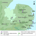
File:The kingdom of East Anglia (Early Saxon period).svg

Size of this PNG preview of this SVG file: 598 × 600 pixels. Other resolutions: 239 × 240 pixels | 479 × 480 pixels | 766 × 768 pixels | 1,021 × 1,024 pixels | 2,042 × 2,048 pixels | 647 × 649 pixels.
Original file (SVG file, nominally 647 × 649 pixels, file size: 511 KB)
File history
Click on a date/time to view the file as it appeared at that time.
| Date/Time | Thumbnail | Dimensions | User | Comment | |
|---|---|---|---|---|---|
| current | 06:19, 19 March 2013 |  | 647 × 649 (511 KB) | Hel-hama | text quality improved |
| 20:14, 20 January 2011 |  | 647 × 649 (235 KB) | Ælfgar | {{Information |Description={{en|Own work, map compiled from a variety of sources: http://www.english-heritage.org.uk/publications/suffolk-rczas-national-mapping-programme-report/nmpfinal02-02-05.pdf (Suffolk coast prior to reclaimation) http://www.devils |
File usage
The following 2 pages use this file:
Global file usage
The following other wikis use this file:
- Usage on be.wikipedia.org
- Usage on de.wikipedia.org
- Usage on gl.wikipedia.org
- Usage on it.wikipedia.org
- Usage on sh.wikipedia.org
- Usage on simple.wikipedia.org
- Usage on sr.wikipedia.org
- Usage on tr.wikipedia.org
