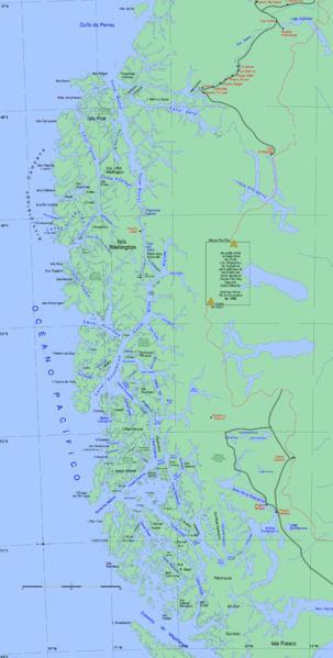
File:Sur1.gif

Size of this preview: 303 × 599 pixels. Other resolutions: 121 × 240 pixels | 243 × 480 pixels | 388 × 768 pixels | 518 × 1,024 pixels | 1,843 × 3,641 pixels.
Original file (1,843 × 3,641 pixels, file size: 657 KB, MIME type: image/gif)
File history
Click on a date/time to view the file as it appeared at that time.
| Date/Time | Thumbnail | Dimensions | User | Comment | |
|---|---|---|---|---|---|
| current | 17:44, 21 April 2013 |  | 1,843 × 3,641 (657 KB) | Keysanger | canal oeste al oeste de c. concepcion. Canal Pitt en vez de C. Pia. Agrego Canal Castro |
| 17:10, 5 March 2013 |  | 1,843 × 3,641 (657 KB) | Keysanger | "Estrecho Nelson" added | |
| 17:06, 5 March 2013 |  | 1,843 × 3,641 (657 KB) | Keysanger | typo fixed: 74°W to 72°W | |
| 01:03, 4 August 2008 |  | 1,843 × 3,641 (675 KB) | Keysanger | {{Information |Description={{en|1=Channels in South-Chile}} |Source=Own work by uploader |Author=Createaccount |Date=2008 |Permission={{GFDL-GMT}}} |other_versions= }} {{ImageUpload|full}} Category:Maps of Chile | |
| 19:28, 24 July 2008 |  | 1,824 × 3,312 (586 KB) | Keysanger | {{Information |Description={{en|1=Channels in South-Chile}} |Source=Own work by uploader |Author=Createaccount |Date=2008 |Permission={{GFDL-GMT}}} |other_versions= }} {{ImageUpload|full}} Category:Maps of Chile |
File usage
The following 17 pages use this file:
- Cerro Castillo, Chile
- Chilean ship Casma (1889)
- Concepción Channel
- Contreras Island
- Fallos Channel
- General Carrera Lake
- Jorge Montt Island
- Ladrillero Channel
- Manuel Rodríguez Island
- Messier Channel
- Nelson Strait (Chile)
- Picton Channel
- Sarmiento Channel
- Saumarez Island
- Smyth Channel
- Trinidad Channel
- Wide Channel
Global file usage
The following other wikis use this file:
- Usage on ar.wikipedia.org
- Usage on arz.wikipedia.org
- Usage on ast.wikipedia.org
- Usage on br.wikipedia.org
- Usage on ceb.wikipedia.org
- Canal Wide
- Isla Presidente Gabriel González Videla
- Isla Manuel Rodríguez
- Isla Figueroa (pulo sa Región de Magallanes y de la Antártica Chilena, lat -50,42, long -74,67)
- Isla Evans (pulo, lat -51,29, long -74,02)
- Canal Concepción
- Isla Cochrane
- Isla Chatham (pulo sa Tśile)
- Isla Barros Arana
- Isla Armonía
- Usage on de.wikipedia.org
- Usage on es.wikipedia.org
View more global usage of this file.

