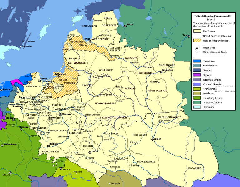
File:Polish-Lithuanian Commonwealth in 1619.PNG

Size of this preview: 768 × 599 pixels. Other resolutions: 308 × 240 pixels | 615 × 480 pixels | 984 × 768 pixels | 1,280 × 999 pixels | 1,996 × 1,558 pixels.
Original file (1,996 × 1,558 pixels, file size: 780 KB, MIME type: image/png)
File history
Click on a date/time to view the file as it appeared at that time.
| Date/Time | Thumbnail | Dimensions | User | Comment | |
|---|---|---|---|---|---|
| current | 18:38, 13 April 2020 |  | 1,996 × 1,558 (780 KB) | Claude Zygiel | Details since Stier, H.-E. (ed.) ''Grosser Atlas zur Weltgeschichte'', Westermann 1985, {{ISBN|3-14-100919-8}}, ''Putzger historischer Weltatlas'', Cornelsen 1990, {{ISBN|3-464-00176-8}}, Sellier, A.J. (ed.) « Atlas des Peuples » -''Europe centrale'', 1992, {{ISBN|2-7071-2032-4}} La Découverte publ., {{ISBN|2-7071-2222-X}}, Unger, M. (ed.) ''Történelmi atlasz'', Hungarian academy 1991, {{ISBN|963-351-422-3}}. |
| 18:54, 27 November 2011 |  | 2,000 × 1,568 (794 KB) | Mathiasrex | Reverted to version as of 10:40, 16 November 2011 | |
| 13:54, 16 November 2011 |  | 2,000 × 1,568 (747 KB) | Mathiasrex | new version | |
| 10:40, 16 November 2011 |  | 2,000 × 1,568 (794 KB) | Mathiasrex | new version | |
| 08:48, 6 February 2009 |  | 2,000 × 1,568 (864 KB) | Mathiasrex | {{Information |Description={{en|1=Polish-Lithuanian Commonwealth in 1619}} |Source=own work |Author=User:Mathiasrex, based on layers of User:Halibutt |Date=2009 |Permission= |other_versions= }} <!--{{ImageUpload|full}}--> |
File usage
The following 5 pages use this file:
Global file usage
The following other wikis use this file:
- Usage on arz.wikipedia.org
- Usage on frr.wikipedia.org
- Usage on is.wikipedia.org
- Usage on ku.wikipedia.org
- Usage on mt.wikipedia.org
- Usage on pt.wikipedia.org
- Usage on sv.wikipedia.org

