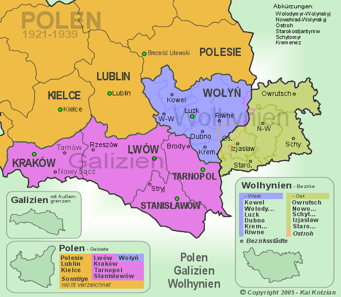
File:Polen Galizien Wolhynien.png

Size of this preview: 688 × 600 pixels. Other resolutions: 275 × 240 pixels | 551 × 480 pixels | 700 × 610 pixels.
Original file (700 × 610 pixels, file size: 152 KB, MIME type: image/png)
File history
Click on a date/time to view the file as it appeared at that time.
| Date/Time | Thumbnail | Dimensions | User | Comment | |
|---|---|---|---|---|---|
| current | 17:44, 25 May 2022 |  | 700 × 610 (152 KB) | Furfur | Reverted to version as of 14:06, 1 May 2005 (UTC) Bukovina was not part of interwar Poland |
| 20:33, 15 November 2011 |  | 700 × 610 (147 KB) | Francis McLloyd | Change border of Stanislawow, know right. add bukowina | |
| 20:30, 15 November 2011 |  | 700 × 610 (147 KB) | Francis McLloyd | ||
| 14:06, 1 May 2005 |  | 700 × 610 (152 KB) | Francis McLloyd | {{CopyrightedFreeUseProvidedThat|the picture has no changes. The copyright holder allows to use the file only in non-commercial intention}} Die Copyrighthinweise sind zu achten! Die Ansicht zeigt den südöstlichen Teil von Polen in den Grenzen von 1921 |
File usage
The following page uses this file:
Global file usage
The following other wikis use this file:
- Usage on an.wikipedia.org
- Usage on ca.wikipedia.org
- Usage on cs.wikipedia.org
- Usage on de.wikipedia.org
- Usage on eo.wikipedia.org
- Usage on es.wikipedia.org
- Usage on fa.wikipedia.org
- Usage on fr.wikipedia.org
- Usage on ja.wikipedia.org
- Usage on nl.wikipedia.org
- Usage on nn.wikipedia.org
- Usage on no.wikipedia.org
- Usage on ru.wikipedia.org
- Usage on sh.wikipedia.org
- Usage on sr.wikipedia.org
- Usage on sv.wikipedia.org
- Usage on tt.wikipedia.org
- Usage on uk.wikipedia.org
- Usage on yi.wikipedia.org


