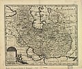
File:Persian(IRAN) Empire 1747.jpg

Size of this preview: 715 × 600 pixels. Other resolutions: 286 × 240 pixels | 572 × 480 pixels | 915 × 768 pixels | 1,220 × 1,024 pixels | 2,441 × 2,048 pixels | 5,420 × 4,548 pixels.
Original file (5,420 × 4,548 pixels, file size: 8.38 MB, MIME type: image/jpeg)
File history
Click on a date/time to view the file as it appeared at that time.
| Date/Time | Thumbnail | Dimensions | User | Comment | |
|---|---|---|---|---|---|
| current | 18:21, 9 July 2012 |  | 5,420 × 4,548 (8.38 MB) | Paris 16 | e |
| 15:40, 31 August 2008 |  | 5,664 × 4,715 (7.22 MB) | Wayiran | {{Information |Description={{en|1=The map of the Persian Empire in 1747 at the time of Afsharid Dynasty}} {{fa|1=نقشهٔ امپراطوری ایران در سال ۱۷۴۷ میلادی برابر با ۱۱۲۶ خورشیدی و ۱۱۶۰ قمری در � |
File usage
The following 12 pages use this file:
Global file usage
The following other wikis use this file:
- Usage on azb.wikipedia.org
- Usage on az.wikipedia.org
- Usage on ckb.wikipedia.org
- Usage on de.wikipedia.org
- Usage on diq.wikipedia.org
- Usage on eo.wikipedia.org
- Usage on et.wikipedia.org
- Usage on fa.wikipedia.org
- دریای عمان
- خلیج فارس
- مشهد
- تاریخ ایران
- نادرشاه
- شهرستان میانه
- میانه (آذربایجان شرقی)
- ایران بزرگ
- ایران افشاری
- کازرون
- نقشهنگاری
- تاریخ ارمنستان
- تحریف نام خلیج فارس
- جغرافیای تاریخی ایران
- ویکیپدیا:گزیدن نگاره برگزیده/دسامبر-۲۰۱۱
- ویکیپدیا:نگارههای برگزیده/نقشه
- ویکیپدیا:نگاره روز/آوریل ۲۰۱۲
- نقشه ایران در دوره افشاریه
- ویکیپدیا:گزیدن نگاره برگزیده/Persian(IRAN) Empire 1747.jpg
- الگو:نر/2012-04-06
- بحث کاربر:Alborzagros/بایگانی ۴
- الگو:نر محافظت شده/2012-04-06
- نقشههای کهن
- ارمنستان ایران (۱۵۰۲–۱۸۲۸)
- فهرست سلسلههای ایران
- بحث:آذربایجان/بایگانی ۲
- Usage on fa.wikibooks.org
- Usage on fr.wikipedia.org
- Usage on hi.wikipedia.org
- Usage on it.wikipedia.org
- Usage on ja.wikipedia.org
- Usage on jv.wikipedia.org
- Usage on ko.wikipedia.org
- Usage on ku.wikipedia.org
- Usage on mzn.wikipedia.org
- Usage on pnb.wikipedia.org
View more global usage of this file.

