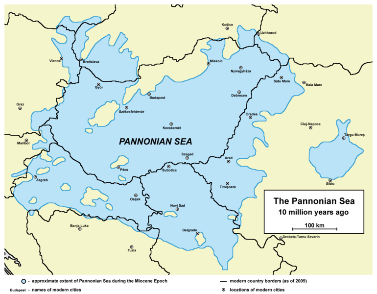
File:Pannoniansea currentborders.png

Size of this preview: 770 × 600 pixels. Other resolutions: 308 × 240 pixels | 617 × 480 pixels | 986 × 768 pixels | 1,280 × 997 pixels | 1,536 × 1,196 pixels.
Original file (1,536 × 1,196 pixels, file size: 119 KB, MIME type: image/png)
File history
Click on a date/time to view the file as it appeared at that time.
| Date/Time | Thumbnail | Dimensions | User | Comment | |
|---|---|---|---|---|---|
| current | 17:26, 5 February 2014 |  | 1,536 × 1,196 (119 KB) | WikiEditor2004 | correcting some errors as modern country borders were not fully accurate fixed on sea borders + some aesthetical improvement |
| 11:20, 23 August 2009 |  | 1,465 × 1,061 (124 KB) | Qorilla | date error | |
| 11:12, 23 August 2009 |  | 1,465 × 1,061 (125 KB) | Qorilla | {{Information |Description=* '''English:''' approximate extent of Pannonian Sea during the Miocene Epoch with modern borders and settlements '''Internet references:''' * [http://www.sulinet.hu/oroksegtar/data/telepulesek_ertekei/Ruzsa/pages/ruzsa_tortene |
File usage
The following 2 pages use this file:
Global file usage
The following other wikis use this file:
- Usage on arz.wikipedia.org
- Usage on bg.wikipedia.org
- Usage on el.wikipedia.org
- Usage on es.wikipedia.org
- Usage on fr.wikipedia.org
- Usage on id.wikipedia.org
- Usage on ja.wikipedia.org
- Usage on kk.wikipedia.org
- Usage on ko.wikipedia.org
- Usage on nn.wikipedia.org
- Usage on no.wikipedia.org
- Usage on pl.wikipedia.org
- Usage on ro.wikipedia.org
- Usage on ru.wikipedia.org
- Usage on www.wikidata.org
- Usage on zh.wikipedia.org
