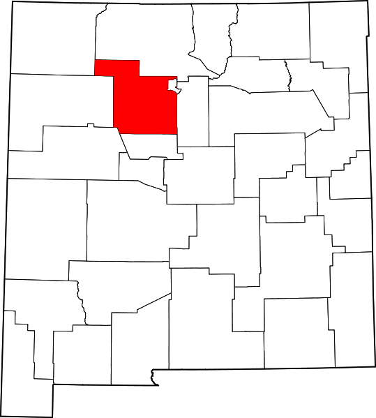
File:Map of New Mexico highlighting Sandoval County.svg

Size of this PNG preview of this SVG file: 539 × 599 pixels. Other resolutions: 216 × 240 pixels | 432 × 480 pixels | 691 × 768 pixels | 921 × 1,024 pixels | 1,842 × 2,048 pixels | 5,677 × 6,312 pixels.
Original file (SVG file, nominally 5,677 × 6,312 pixels, file size: 31 KB)
File history
Click on a date/time to view the file as it appeared at that time.
| Date/Time | Thumbnail | Dimensions | User | Comment | |
|---|---|---|---|---|---|
| current | 00:07, 6 July 2024 |  | 5,677 × 6,312 (31 KB) | Nux | fix rendering (remove clipping), uniform colors |
| 15:31, 12 February 2006 |  | 5,677 × 6,312 (31 KB) | David Benbennick | {{subst:User:Dbenbenn/clm|county=Sandoval County|state=New Mexico|type=county}} |
File usage
The following 41 pages use this file:
- Algodones, New Mexico
- Bernalillo, New Mexico
- Cañon, New Mexico
- Cochiti, New Mexico
- Cochiti Lake, New Mexico
- Corrales, New Mexico
- Counselor, New Mexico
- Cuba, New Mexico
- Edgewood, New Mexico
- Hagan, New Mexico
- Jemez Pueblo, New Mexico
- Jemez Springs, New Mexico
- La Cueva, Sandoval County, New Mexico
- La Jara, New Mexico
- La Madera, Sandoval County, New Mexico
- List of Navajo Nation Chapters
- List of counties in New Mexico
- Mesa Prieta
- National Register of Historic Places listings in Sandoval County, New Mexico
- Navajo Nation
- Peña Blanca, New Mexico
- Placitas, Sandoval County, New Mexico
- Ponderosa, New Mexico
- Pueblo of Sandia Village, New Mexico
- Regina, New Mexico
- Rio Rancho, New Mexico
- Rio Rancho Estates, New Mexico
- San Felipe Pueblo, New Mexico
- San Luis, New Mexico
- San Ysidro, Sandoval County, New Mexico
- Sandia Pueblo
- Sandoval County, New Mexico
- Santa Ana Pueblo
- Santa Clara Indian Reservation
- Santo Domingo Pueblo, New Mexico
- Torreon, Sandoval County, New Mexico
- Zia Pueblo, New Mexico
- User:AridCeption/sandbox
- User:Nyttend/County templates/NM
- Template:Sandoval County, New Mexico
- Category:Populated places in Sandoval County, New Mexico
Global file usage
The following other wikis use this file:
- Usage on ar.wikipedia.org
- كوراليس (نيومكسيكو)
- ريو رانتشو (نيومكسيكو)
- مقاطعة ساندوفال (نيومكسيكو)
- جيمز سبرينغز (نيومكسيكو)
- سان يسيدرو (نيومكسيكو)
- كوبا (نيومكسيكو)
- إدغوود (نيومكسيكو)
- محمية نافاجو
- سانتو دومينغو بويبلو (نيومكسيكو)
- سانتا آنا بويبلو (نيومكسيكو)
- سان فيليبي بويبلو (نيومكسيكو)
- بينيا بيانكا (نيومكسيكو)
- زيا بويبلو (نيومكسيكو)
- سان إلديفونسو بويبلو (نيومكسيكو)
- بيرناليلو (نيومكسيكو)
- لا جارا (نيومكسيكو)
- جيمز بويبلو (نيومكسيكو)
- قالب:مقاطعة ساندوفال (نيومكسيكو)
- Usage on bg.wikipedia.org
- Usage on bpy.wikipedia.org
- Usage on ca.wikipedia.org
- Sandia
- Pueblo Jemez
- Cochiti
- San Felipe Pueblo
- Kewa Pueblo
- Zia
- Santa Ana Pueblo
- Kawaik
- Algodones
- Bernalillo
- Cuba (Nou Mèxic)
- Edgewood (Nou Mèxic)
- Jemez Springs
- La Jara (Nou Mèxic)
- Pena Blanca
- Placitas
- Ponderosa (Nou Mèxic)
- Pueblo of Sandia Village
- Regina (Nou Mèxic)
- Rio Rancho
- San Ysidro
- Nació Navajo
- Plantilla:Comtat de Sandoval
- Reserva índia Santa Clara
- Jicarilles
- Usage on cdo.wikipedia.org
- Usage on ceb.wikipedia.org
- Usage on ce.wikipedia.org
- Usage on cy.wikipedia.org
View more global usage of this file.
