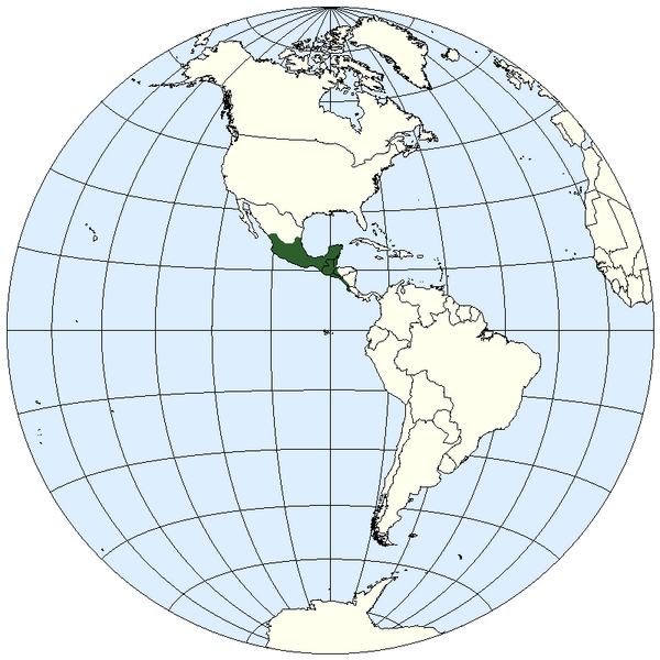
File:LocationWHMesoamerica.png

Size of this preview: 600 × 600 pixels. Other resolutions: 240 × 240 pixels | 480 × 480 pixels.
Original file (800 × 800 pixels, file size: 30 KB, MIME type: image/png)
| Description |
Map of Western Hemisphere, with Mesoamerica highlighted |
|---|---|
| Source |
maps at 'Americas (terminology)' |
| Date |
7 February 2009 |
| Author |
Ixtapl |
| Permission (Reusing this file) |
See below.
|
File history
Click on a date/time to view the file as it appeared at that time.
| Date/Time | Thumbnail | Dimensions | User | Comment | |
|---|---|---|---|---|---|
| current | 03:41, 6 August 2009 |  | 800 × 800 (30 KB) | AlexCovarrubias (talk | contribs) | |
| 16:13, 8 February 2009 |  | 800 × 800 (43 KB) | Ixtapl (talk | contribs) | Map of Western Hemisphere, with Mesoamerica highlighted (darn it!) | |
| 16:09, 8 February 2009 |  | 800 × 800 (43 KB) | Ixtapl (talk | contribs) | Map of Western Hemisphere, with Mesoamerica highlighted | |
| 05:08, 8 February 2009 |  | 800 × 800 (50 KB) | Ixtapl (talk | contribs) | Map of Western Hemisphere, with Mesoamerica highlighted | |
| 03:07, 8 February 2009 |  | 800 × 800 (43 KB) | Ixtapl (talk | contribs) | Map of Western Hemisphere, with Mesoamerica highlighted | |
| 02:35, 8 February 2009 |  | 800 × 800 (43 KB) | Ixtapl (talk | contribs) | Map of Western Hemisphere, with Mesoamerica highlighted | |
| 01:27, 8 February 2009 |  | 800 × 800 (43 KB) | Ixtapl (talk | contribs) | {{Information |Description=Map of Western Hemisphere, with Mesoamerica highlighted |Source=maps at 'Americas (terminology)' |Date=7 February 2009 |Author=Ixtapl |Permission= |other_versions= }} |
You cannot overwrite this file.
File usage
The following page uses this file:
