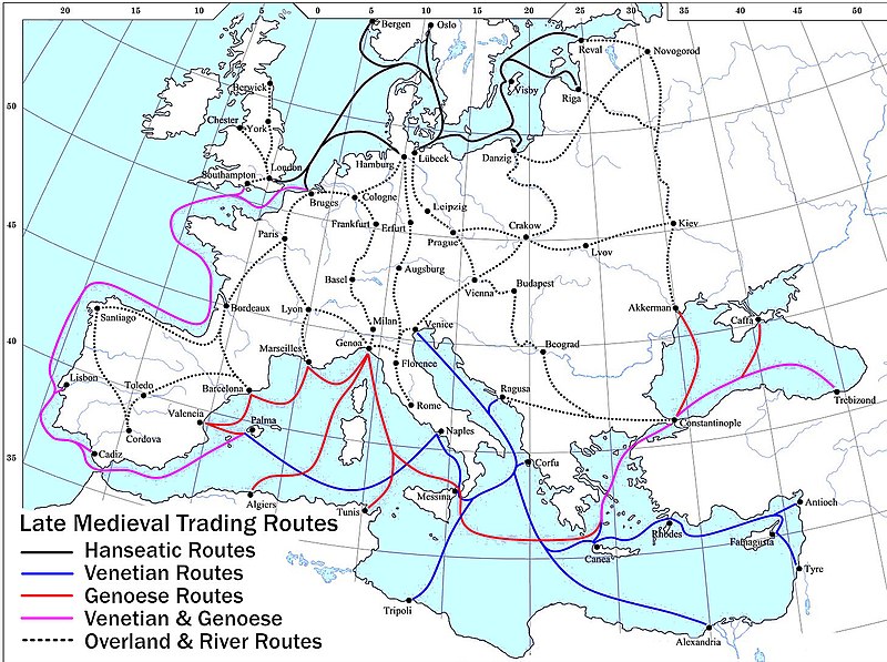
File:Late Medieval Trade Routes.jpg

Size of this preview: 800 × 597 pixels. Other resolutions: 320 × 239 pixels | 640 × 478 pixels | 1,024 × 765 pixels | 1,280 × 956 pixels | 1,457 × 1,088 pixels.
Original file (1,457 × 1,088 pixels, file size: 372 KB, MIME type: image/jpeg)
File history
Click on a date/time to view the file as it appeared at that time.
| Date/Time | Thumbnail | Dimensions | User | Comment | |
|---|---|---|---|---|---|
| current | 20:46, 18 May 2022 |  | 1,457 × 1,088 (372 KB) | Richard2s | Clearer key for map |
| 20:25, 23 January 2011 |  | 853 × 544 (453 KB) | Micsha~commonswiki | Includes map key on the map | |
| 15:55, 28 March 2008 |  | 1,817 × 1,120 (487 KB) | Lampman | {{Information |Description=Map showing the main trade routes of late medieval Europe. The black lines show the routes of the Hanseatic League, the blue Venetian and the red Genoese routes. Purple lines are routes used by both the Venetians and the Genoese |
File usage
The following 9 pages use this file:
- Economics
- Islamic influences on Western art
- Late Middle Ages
- Trade
- Wikipedia:Picture peer review/Archives/Jan-Mar 2008
- Wikipedia:Picture peer review/Late medieval trade routes
- Wikipedia:Valued picture candidates/January-2009
- Wikipedia:Valued picture candidates/Late Medieval Trade Routes
- Portal:Economics
Global file usage
The following other wikis use this file:
- Usage on ar.wikipedia.org
- Usage on be-tarask.wikipedia.org
- Usage on bg.wikipedia.org
- Usage on ca.wikipedia.org
- Usage on da.wikipedia.org
- Usage on el.wikipedia.org
- Usage on es.wikipedia.org
- Usage on et.wikipedia.org
- Usage on fr.wikipedia.org
- Usage on he.wikipedia.org
- Usage on hy.wikipedia.org
- Usage on it.wikipedia.org
- Usage on ja.wikipedia.org
- Usage on mk.wikipedia.org
- Usage on nl.wikipedia.org
- Usage on pl.wikipedia.org
- Usage on pt.wikipedia.org
- Usage on rm.wikipedia.org
- Usage on sh.wikipedia.org
- Usage on sl.wikipedia.org
- Usage on sq.wikipedia.org
- Usage on th.wikipedia.org
- Usage on uk.wikipedia.org
- Usage on vi.wikipedia.org
- Usage on www.wikidata.org


