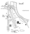
File:Houghton Lake State Airport map.png

Size of this preview: 525 × 600 pixels. Other resolutions: 210 × 240 pixels | 420 × 480 pixels | 700 × 800 pixels.
Original file (700 × 800 pixels, file size: 121 KB, MIME type: image/png)
File history
Click on a date/time to view the file as it appeared at that time.
| Date/Time | Thumbnail | Dimensions | User | Comment | |
|---|---|---|---|---|---|
| current | 04:49, 27 July 2020 |  | 700 × 800 (121 KB) | Notorious4life | == {{int:filedesc}} == {{Convert to SVG|architecture}} {{Information |Description= {{en|1=Airport diagram for Houghton Lake State Airport (5Y2) in Roscommon Township, Michigan, United States.}} |Source= https://www.michigan.gov/documents/aero/Houghton_Lake_State_385397_7.pdf |Author= Federal Aviation Administration (FAA). |Date=No date given |Permission= Publi... |
File usage
The following page uses this file:


