Original file (SVG file, nominally 938 × 1,119 pixels, file size: 534 KB)
Summary
Licensing I, the copyright holder of this work, hereby publish it under the following license:
You are free:
to share – to copy, distribute and transmit the workto remix – to adapt the work
Under the following conditions:
attribution – You must give appropriate credit, provide a link to the license, and indicate if changes were made. You may do so in any reasonable manner, but not in any way that suggests the licensor endorses you or your use.share alike – If you remix, transform, or build upon the material, you must distribute your contributions under the same or compatible license as the original. https://creativecommons.org/licenses/by-sa/3.0 CC BY-SA 3.0 Creative Commons Attribution-Share Alike 3.0 true true English Add a one-line explanation of what this file represents
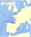
Spanish Rutas comerciales y pesquerías de la Hermandad de las Cuatro Villas
File history
Click on a date/time to view the file as it appeared at that time.
Date/Time Thumbnail Dimensions User Comment current 15:42, 31 October 2022 938 × 1,119 (534 KB) Lojwe Perfeccionamiento de los bordes 08:31, 31 August 2009 938 × 1,119 (550 KB) Tony Rotondas 09:13, 30 August 2009 938 × 1,119 (538 KB) Tony Rotondas 18:43, 29 August 2009 938 × 1,119 (530 KB) VanKleinen fixing 17:48, 29 August 2009 938 × 1,119 (105 KB) Tony Rotondas Category:Maps of Cantabria Category:Maps showing 15th-century history Category:Maps of the history of Europe Category:History of Cantabria Category:Spain in the 15th century 17:47, 29 August 2009 938 × 1,119 (105 KB) Tony Rotondas Category:Maps of Cantabria Category:Maps showing 15th-century history Category:Maps of the history of Europe Category:History of Cantabria Category:Spain in the 15th century 17:43, 29 August 2009 938 × 1,119 (105 KB) Tony Rotondas Category:Maps of Cantabria Category:Maps showing 15th-century history Category:Maps of the history of Europe Category:History of Cantabria Category:Spain in the 15th century 17:43, 29 August 2009 938 × 1,119 (106 KB) Tony Rotondas Category:Maps of Cantabria Category:Maps showing 15th-century history Category:Maps of the history of Europe Category:History of Cantabria Category:Spain in the 15th century 17:42, 29 August 2009 938 × 1,119 (105 KB) Tony Rotondas Category:Maps of Cantabria Category:Maps showing 15th-century history Category:Maps of the history of Europe Category:History of Cantabria Category:Spain in the 15th century 17:41, 29 August 2009 938 × 1,119 (105 KB) Tony Rotondas Category:Maps of Cantabria Category:Maps showing 15th-century history Category:Maps of the history of Europe Category:History of Cantabria Category:Spain in the 15th century
File usage
The following 2 pages use this file:
Global file usage The following other wikis use this file:
Usage on eo.wikipedia.org
Usage on es.wikipedia.org
Usage on pt.wikipedia.org
Usage on ru.wikipedia.org
Usage on sl.wikipedia.org
This file contains additional information, probably added from the digital camera or scanner used to create or digitize it.
If the file has been modified from its original state, some details may not fully reflect the modified file.


