
File:HawRiverMap1781.jpg

Size of this preview: 664 × 599 pixels. Other resolutions: 266 × 240 pixels | 532 × 480 pixels | 770 × 695 pixels.
Original file (770 × 695 pixels, file size: 219 KB, MIME type: image/jpeg)
Summary
| Description |
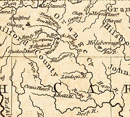
A portion of Kitchin's 1791 map of North Carolina, featuring the locations of military interest from the American Revolutionary War, which depicts the territory between Hillsborough and Guilford Courthouse. |
|---|---|
| Source |
Original publication: London Magazine |
| Date |
June, 1781 |
| Author |
Thomas Kitchin |
| Permission (Reusing this file) |
See below.
|
Licensing
File history
Click on a date/time to view the file as it appeared at that time.
| Date/Time | Thumbnail | Dimensions | User | Comment | |
|---|---|---|---|---|---|
| current | 19:40, 24 January 2013 | | 770 × 695 (219 KB) | Cdtew (talk | contribs) | Uploading an old public-domain work using File Upload Wizard |
You cannot overwrite this file.
File usage
The following 2 pages use this file: