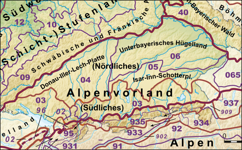
File:Haupteinheitengruppen Alpenvorland und Alpen.png

Size of this preview: 800 × 499 pixels. Other resolutions: 320 × 200 pixels | 640 × 399 pixels | 1,000 × 624 pixels.
Original file (1,000 × 624 pixels, file size: 1.09 MB, MIME type: image/png)
File history
Click on a date/time to view the file as it appeared at that time.
| Date/Time | Thumbnail | Dimensions | User | Comment | |
|---|---|---|---|---|---|
| current | 19:08, 23 December 2020 |  | 1,000 × 624 (1.09 MB) | Elop | |
| 19:31, 25 December 2014 |  | 1,000 × 624 (1.08 MB) | Elop | update | |
| 13:48, 2 July 2012 |  | 1,000 × 623 (1,016 KB) | Elop | Alpen nochmal überarbeitet | |
| 21:48, 1 July 2012 |  | 1,000 × 581 (939 KB) | Elop | k | |
| 16:34, 1 July 2012 |  | 1,000 × 559 (906 KB) | Elop | update | |
| 15:03, 27 May 2012 |  | 1,000 × 614 (980 KB) | Elop | ||
| 00:46, 25 October 2011 |  | 1,000 × 614 (1.76 MB) | Elop | k | |
| 13:07, 24 October 2011 |  | 1,000 × 625 (1.79 MB) | Elop | more details | |
| 13:53, 2 October 2011 |  | 913 × 620 (1.62 MB) | Elop | == {{int:filedesc}} == {{Information |Description={{de|1=Haupteinheitengruppen der Westlichen Mittelgebirge}} |Source=*Deutschland_Naturräumliche_Haupteinheiten.png |Author=*derivative work: [[Use |
File usage
The following 2 pages use this file:
Global file usage
The following other wikis use this file:
- Usage on de.wikipedia.org
- Bayerisches Alpenvorland
- Naturräumliche Großregionen Deutschlands
- Holzstöcke
- Unterbayerisches Hügelland
- Tertiärhügelland
- Donau-Iller-Lech-Platte
- Diskussion:Oberschwaben/Archiv
- Vorlage:Positionskarte Deutschland Naturraum Alpenvorland und Alpen
- Unteres Illertal
- Donau-Ablach-Platten
- Naturräumliche Gliederung der Alpen
- Subalpines Jungmoränenland
- Grassauer Almen
- Benutzer:Triplec85/BW-1
- Usage on uk.wikipedia.org
- Usage on www.wikidata.org


