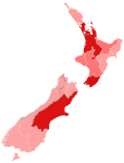
File:H1N1 New Zealand confirmed cases.png
H1N1_New_Zealand_confirmed_cases.png (405 × 590 pixels, file size: 12 KB, MIME type: image/png)
File history
Click on a date/time to view the file as it appeared at that time.
| Date/Time | Thumbnail | Dimensions | User | Comment | |
|---|---|---|---|---|---|
| current | 02:24, 8 July 2009 |  | 405 × 590 (12 KB) | Lcmortensen | recolour Taranaki |
| 02:11, 7 July 2009 |  | 405 × 590 (12 KB) | Lcmortensen | update to 6 July - recoloured Waikato | |
| 08:41, 5 July 2009 |  | 405 × 590 (12 KB) | Lcmortensen | updated to 5 July - change colours of Hawke's Bay, Otago and Southalnd | |
| 07:30, 1 July 2009 |  | 405 × 590 (12 KB) | Lcmortensen | update | |
| 04:24, 24 June 2009 |  | 405 × 590 (12 KB) | Lcmortensen | {{Information |Description={{en|A map showing the number of confirmed cases of H1N1 in New Zealand regions.}} |Source= Devired from File:Swine Flu map NZ.PNG using data from New Zealand Ministry of Health and District Health Boards. |Date=2009-06-24 |
File usage
The following 7 pages use this file:
Global file usage
The following other wikis use this file:
- Usage on es.wikipedia.org
- Usage on fr.wikipedia.org
- Usage on pt.wikipedia.org


