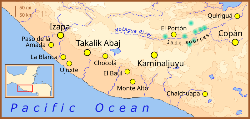
File:Formative Period southern Mesoamerica 2.svg

Size of this PNG preview of this SVG file: 800 × 380 pixels. Other resolutions: 320 × 152 pixels | 640 × 304 pixels | 1,024 × 486 pixels | 1,280 × 608 pixels | 2,560 × 1,215 pixels | 1,241 × 589 pixels.
Original file (SVG file, nominally 1,241 × 589 pixels, file size: 252 KB)
File history
Click on a date/time to view the file as it appeared at that time.
| Date/Time | Thumbnail | Dimensions | User | Comment | |
|---|---|---|---|---|---|
| current | 01:22, 9 February 2008 |  | 1,241 × 589 (252 KB) | Madman2001 | Fixed mistake and added another site |
| 18:04, 7 February 2008 |  | 1,241 × 589 (252 KB) | Madman2001 | fixed earlier mistake | |
| 17:41, 7 February 2008 |  | 1,241 × 589 (224 KB) | Madman2001 | smaller formating changes | |
| 13:14, 7 February 2008 |  | 1,241 × 589 (234 KB) | Madman2001 | {{Information |Description=A map of the southern-most area of Mesoamerica, showing important Formative Period sites. |Source=self-made |Date=February 2008 |Author= Madman2001 |Permission= |other_versions= }} |
File usage
The following 14 pages use this file:
Global file usage
The following other wikis use this file:
- Usage on af.wikipedia.org
- Usage on ar.wikipedia.org
- Usage on be.wikipedia.org
- Usage on bs.wikipedia.org
- Usage on de.wikipedia.org
- Usage on es.wikipedia.org
- Usage on fi.wikipedia.org
- Usage on fi.wikibooks.org
- Usage on fr.wikipedia.org
- Usage on he.wikipedia.org
- Usage on hr.wikipedia.org
- Usage on hu.wikipedia.org
- Usage on id.wikipedia.org
- Usage on it.wikipedia.org
- Usage on ja.wikipedia.org
- Usage on ka.wikipedia.org
- Usage on lt.wikipedia.org
- Usage on nl.wikipedia.org
- Usage on pt.wikipedia.org
- Usage on ru.wikipedia.org
- Usage on sh.wikipedia.org
- Usage on sv.wikipedia.org
- Usage on uk.wikipedia.org
- Usage on www.wikidata.org
- Usage on zh.wikipedia.org
