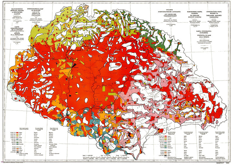
File:Ethnographic map of hungary 1910 by teleki carte rouge.jpg

Size of this preview: 800 × 566 pixels. Other resolutions: 320 × 226 pixels | 640 × 453 pixels | 1,024 × 724 pixels | 1,280 × 905 pixels | 2,560 × 1,810 pixels | 4,962 × 3,509 pixels.
Original file (4,962 × 3,509 pixels, file size: 5.18 MB, MIME type: image/jpeg)
File history
Click on a date/time to view the file as it appeared at that time.
| Date/Time | Thumbnail | Dimensions | User | Comment | |
|---|---|---|---|---|---|
| current | 16:46, 22 January 2016 |  | 4,962 × 3,509 (5.18 MB) | Qorilla | removed some noise, dots, smears |
| 18:32, 28 December 2009 |  | 4,962 × 3,509 (4.6 MB) | Qorilla | whitening and other improvements | |
| 13:57, 2 December 2009 |  | 4,962 × 3,509 (3.11 MB) | Bercess | {{Information |Description={{en|1=Ethnographic map of Hungary, based on the density of population according to the census of 1910. Original scale 1 : 1 000 000. Every square millimeter colored indicates 100 inhabitants. "Carte Rouge" - "Red map" was made |
File usage
The following 10 pages use this file:
Global file usage
The following other wikis use this file:
- Usage on ast.wikipedia.org
- Usage on azb.wikipedia.org
- Usage on bn.wikipedia.org
- Usage on ca.wikipedia.org
- Usage on cs.wikipedia.org
- Usage on cy.wikipedia.org
- Usage on de.wikipedia.org
- Usage on el.wikipedia.org
- Usage on es.wikipedia.org
- Usage on et.wikipedia.org
- Usage on fa.wikipedia.org
- Usage on fi.wikipedia.org
- Usage on fr.wikipedia.org
- Usage on hr.wikipedia.org
- Usage on hu.wikipedia.org
- Usage on id.wikipedia.org
- Usage on ko.wikipedia.org
- Usage on la.wikipedia.org
- Usage on pl.wikipedia.org
- Usage on sl.wikipedia.org
- Usage on sr.wikipedia.org
- Usage on tr.wikipedia.org
- Usage on uk.wikipedia.org
- Usage on www.wikidata.org

