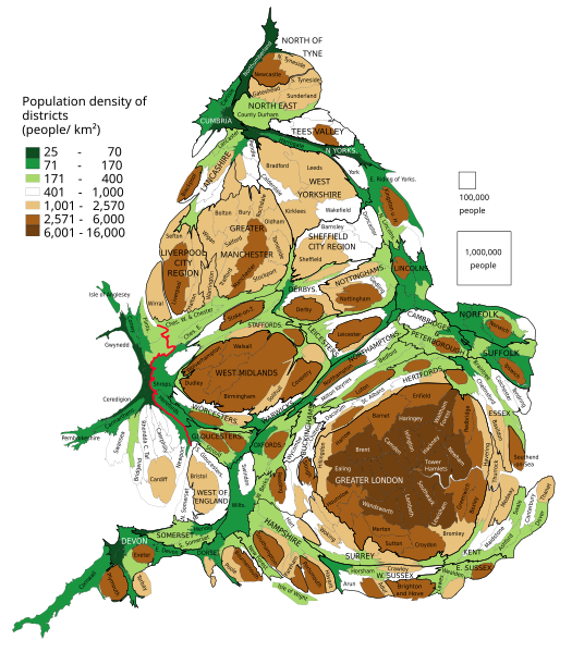
File:England and Wales population cartogram districts.svg

Size of this PNG preview of this SVG file: 525 × 599 pixels. Other resolutions: 210 × 240 pixels | 421 × 480 pixels | 673 × 768 pixels | 897 × 1,024 pixels | 1,795 × 2,048 pixels | 1,022 × 1,166 pixels.
Original file (SVG file, nominally 1,022 × 1,166 pixels, file size: 805 KB)
File history
Click on a date/time to view the file as it appeared at that time.
| Date/Time | Thumbnail | Dimensions | User | Comment | |
|---|---|---|---|---|---|
| current | 17:14, 13 February 2019 |  | 1,022 × 1,166 (805 KB) | PawełS | combined authorities |
| 21:08, 22 March 2017 |  | 1,022 × 1,166 (783 KB) | PawełS | Haringey and Devon font colour | |
| 14:34, 19 March 2017 |  | 1,022 × 1,166 (783 KB) | PawełS | + population density | |
| 18:01, 16 January 2014 |  | 1,024 × 1,188 (1 MB) | PawełS | Fonts size | |
| 17:49, 16 January 2014 |  | 1,024 × 1,188 (1.1 MB) | PawełS | Bold England-Wales border | |
| 20:01, 24 March 2013 |  | 1,024 × 1,188 (1.1 MB) | PawełS | Trying to fix fonts appearance in thumb | |
| 18:16, 14 March 2013 |  | 1,024 × 1,188 (1.1 MB) | PawełS | User created page with UploadWizard |
File usage
The following page uses this file:
Global file usage
The following other wikis use this file:
- Usage on fi.wikipedia.org
- Usage on is.wikipedia.org
- Usage on ku.wikipedia.org
- Usage on pl.wikipedia.org
- Usage on vi.wikipedia.org
