Langbahn Team – Weltmeisterschaft

File:DoreenAug519692135UTCESSA9.gif

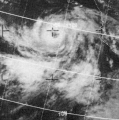
DoreenAug519692135UTCESSA9.gif (445 × 447 pixels, file size: 239 KB, MIME type: image/gif)

Summary

Description
English: This ESSA 9 weather satellite image of Hurricane Doreen was taken on August 5, 1969 at 2135 UTC
Date
Source Mariners Weather Log, November 1969, pg. 292
Author ESSA, forerunner of NOAA
Camera location19° 00′ 00″ N, 111° 00′ 00″ W Kartographer map based on OpenStreetMap.View this and other nearby images on: OpenStreetMapinfo

Licensing

Public domain
This image is in the public domain because it contains materials that originally came from the U.S. National Oceanic and Atmospheric Administration, taken or made as part of an employee's official duties.

العربية  čeština  Deutsch  Zazaki  English  español  eesti  suomi  français  hrvatski  magyar  italiano  日本語  한국어  македонски  മലയാളം  Plattdüütsch  Nederlands  polski  português  română  русский  sicilianu  slovenščina  Türkçe  Tiếng Việt  简体中文  繁體中文 

Captions

Add a one-line explanation of what this file represents

Items portrayed in this file

depicts

copyright status

public domain

applies to jurisdiction: United States
determination method or standard: work of the federal government of the United States

inception

18 March 2013

coordinates of the point of view

19°N, 111°W

data size

244,233 byte

height

447 pixel

width

445 pixel

media type

image/gif

checksum

c2d289479666d4e9b9a8543eeb008a58b2a054f1

determination method or standard: SHA-1

File history

Click on a date/time to view the file as it appeared at that time.

Date/TimeThumbnailDimensionsUserComment
current00:38, 19 March 2013Thumbnail for version as of 00:38, 19 March 2013445 × 447 (239 KB)ThegreatdrUser created page with UploadWizard

The following page uses this file: