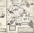
File:Desceliers 1550 map - Australia detail.jpg

Size of this preview: 628 × 600 pixels. Other resolutions: 251 × 240 pixels | 503 × 480 pixels | 804 × 768 pixels | 1,072 × 1,024 pixels | 2,145 × 2,048 pixels | 2,711 × 2,589 pixels.
Original file (2,711 × 2,589 pixels, file size: 1.1 MB, MIME type: image/jpeg)
File history
Click on a date/time to view the file as it appeared at that time.
| Date/Time | Thumbnail | Dimensions | User | Comment | |
|---|---|---|---|---|---|
| current | 01:03, 2 May 2008 |  | 2,711 × 2,589 (1.1 MB) | Hesperian | colour balanced |
| 12:34, 20 February 2008 |  | 2,711 × 2,589 (920 KB) | Hesperian | much higher resolution | |
| 12:18, 28 December 2007 |  | 732 × 696 (191 KB) | Hesperian | {{Information |Description=This is a detail from a 1550 world map by Pierre Desceliers, from the location where Australia would be, and purportedly showing Australian features. It is one of the Dieppe maps, which are commonly put forward as eviden |
File usage
The following 4 pages use this file:
Global file usage
The following other wikis use this file:
- Usage on ca.wikipedia.org
- Usage on es.wikipedia.org
- Usage on fr.wikipedia.org
- Usage on id.wikipedia.org
- Usage on it.wikipedia.org
- Usage on ja.wikipedia.org
- Usage on nl.wikipedia.org
- Usage on pt.wikipedia.org
- Usage on www.wikidata.org

