Langbahn Team – Weltmeisterschaft

File:DST Countries Map.png
Original file (4,952 × 2,197 pixels, file size: 462 KB, MIME type: image/png)

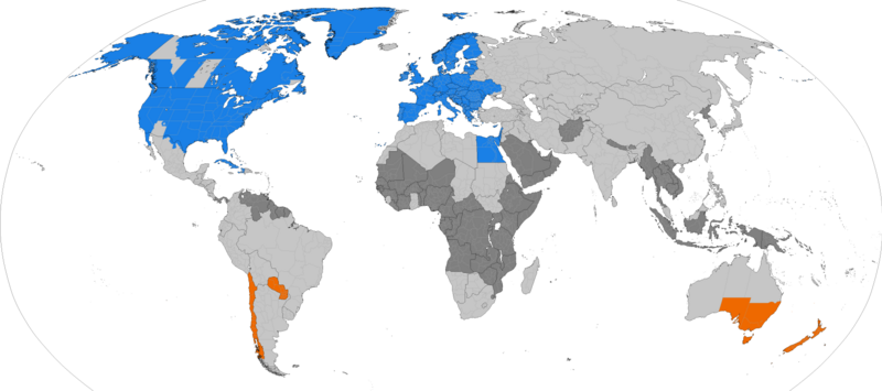
Dark grey places have never used daylight savings, light grey places formerly used it. Orange places use daylight savings in the southern hemisphere summer. Blue places use daylight savings in the northern hemisphere summer.


This file may be updated to reflect new information.
If you wish to use a specific version of the file without it being overwritten, please upload the required version as a separate file.
This map of the world image could be re-created using vector graphics as an SVG file. This has several advantages; see Commons:Media for cleanup for more information. If an SVG form of this image is available, please upload it and afterwards replace this template with {{vector version available|new image name}}.


It is recommended to name the SVG file “DST Countries Map.svg”—then the template Vector version available (or Vva) does not need the new image name parameter.

Summary

Description
English: Larger map of the previous version. Distinguished from summertime in the northern hemisphere and southern hemisphere.
 
Northern hemisphere summer
 
Southern hemisphere summer
 
Formerly used daylight savings
 
Never used daylight savings
Bahasa Indonesia: Peta yang lebih besar dari versi sebelumnya. Membedakan masa musim panas di belahan bumi utara dan selatan.
 
Musim panas belahan bumi utara
 
Musim panas belahan bumi utara
 
Menggunakan waktu musim panas di masa lampau
 
Tidak pernah menggunakan waktu musim panas
Date
Source Own work
Author TimeZonesBoy
Other versions Supplementary map:

Licensing

I, the copyright holder of this work, hereby publish it under the following license:
w:en:Creative Commons
attribution share alike
This file is licensed under the Creative Commons Attribution-Share Alike 3.0 Unported license.
You are free:
  • to share – to copy, distribute and transmit the work
  • to remix – to adapt the work
Under the following conditions:
  • attribution – You must give appropriate credit, provide a link to the license, and indicate if changes were made. You may do so in any reasonable manner, but not in any way that suggests the licensor endorses you or your use.
  • share alike – If you remix, transform, or build upon the material, you must distribute your contributions under the same or compatible license as the original.
Any autoconfirmed user can overwrite this file from the same source. Please ensure that overwrites comply with the guideline.

Captions

Countries that observe Daylight Saving Time

Items portrayed in this file

depicts

daylight saving time

creator

some value

author name string: TimeZonesBoy
Wikimedia username: TimeZonesBoy

copyright status

copyrighted

copyright license

Creative Commons Attribution-ShareAlike 3.0 Unported

inception

30 May 2013

source of file

original creation by uploader

media type

image/png

checksum

5c6a329d85ba78e7f4f653fe6cd3bee3e3620b1e

determination method or standard: SHA-1

data size

473,382 byte

height

2,197 pixel

width

4,952 pixel

File history

Click on a date/time to view the file as it appeared at that time.

(newest | oldest) View (newer 10 | ) (10 | 20 | 50 | 100 | 250 | 500)
Date/TimeThumbnailDimensionsUserComment
current00:30, 15 October 2024Thumbnail for version as of 00:30, 15 October 20244,952 × 2,197 (462 KB)HeitordpUpdated Paraguay
06:06, 31 March 2024Thumbnail for version as of 06:06, 31 March 20244,952 × 2,197 (462 KB)HeitordpAdjusted Greenland
11:27, 31 December 2023Thumbnail for version as of 11:27, 31 December 20234,952 × 2,197 (462 KB)HeitordpUpdated Greenland, disputed borders, subdivisions of France, Morocco, DR Congo, South Sudan, Ethiopia, Somalia, India
09:44, 23 April 2023Thumbnail for version as of 09:44, 23 April 20234,952 × 2,197 (463 KB)HeitordpUpdated Ukraine
21:51, 5 April 2023Thumbnail for version as of 21:51, 5 April 20234,952 × 2,197 (463 KB)HeitordpUpdated most of Greenland, law specifies UTC–2 with no DST in 2023
13:30, 27 March 2023Thumbnail for version as of 13:30, 27 March 20234,952 × 2,197 (462 KB)HeitordpCorrected northeast Greenland and Qikiqtaaluk island
20:58, 1 March 2023Thumbnail for version as of 20:58, 1 March 20234,952 × 2,197 (462 KB)HeitordpUpdated Egypt, adjusted Kazakhstan
06:48, 30 November 2022Thumbnail for version as of 06:48, 30 November 20224,952 × 2,197 (462 KB)HeitordpUpdated Mexico
08:01, 20 November 2022Thumbnail for version as of 08:01, 20 November 20224,952 × 2,197 (462 KB)HeitordpRemoved Antarctica, added globe outline
09:29, 30 October 2022Thumbnail for version as of 09:29, 30 October 20224,972 × 2,492 (466 KB)HeitordpUpdated Mexico; adjusted US, Canada, Greenland
(newest | oldest) View (newer 10 | ) (10 | 20 | 50 | 100 | 250 | 500)

Global file usage

The following other wikis use this file:

Metadata