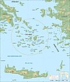
File:Cyclades map-fr.jpg

Size of this preview: 509 × 600 pixels. Other resolutions: 204 × 240 pixels | 407 × 480 pixels | 652 × 768 pixels | 869 × 1,024 pixels | 1,738 × 2,048 pixels | 3,680 × 4,335 pixels.
Original file (3,680 × 4,335 pixels, file size: 1.98 MB, MIME type: image/jpeg)
File history
Click on a date/time to view the file as it appeared at that time.
| Date/Time | Thumbnail | Dimensions | User | Comment | |
|---|---|---|---|---|---|
| current | 07:36, 20 July 2019 |  | 3,680 × 4,335 (1.98 MB) | Julieta39 | Esthetic (near Ikaria which is not a Cycladic island) |
| 15:38, 19 July 2019 |  | 3,680 × 4,335 (2 MB) | Julieta39 | A circle | |
| 22:11, 17 July 2010 |  | 3,680 × 4,335 (1.99 MB) | Sting | Color profile | |
| 17:52, 4 September 2008 |  | 3,680 × 4,335 (1.86 MB) | Sting | == Summary == {{Information |Description={{en|Map in French of the Cyclades islands, Greece.}} {{fr|Carte des îles Cyclades, Grèce.}} UTM projection ; WGS84 datum ; shaded relief |Source=Own work ;<br/> *Topographic da |
File usage
The following 3 pages use this file:
Global file usage
The following other wikis use this file:
- Usage on af.wikipedia.org
- Usage on ang.wikipedia.org
- Usage on ast.wikipedia.org
- Usage on be.wikipedia.org
- Usage on ca.wikipedia.org
- Usage on en.wikiversity.org
- Usage on eo.wikipedia.org
- Usage on eo.wikivoyage.org
- Usage on es.wikipedia.org
- Usage on eu.wikipedia.org
- Usage on fa.wikipedia.org
- Usage on fr.wikipedia.org
- Usage on gl.wikipedia.org
- Usage on hyw.wikipedia.org
- Usage on id.wikipedia.org
- Usage on it.wikipedia.org
- Usage on ku.wikipedia.org
View more global usage of this file.


