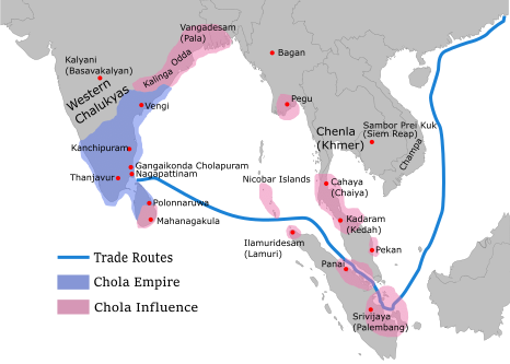
File:Chola Empire map2.png
Chola_Empire_map2.png (466 × 333 pixels, file size: 85 KB, MIME type: image/png)
File history
Click on a date/time to view the file as it appeared at that time.
| Date/Time | Thumbnail | Dimensions | User | Comment | |
|---|---|---|---|---|---|
| current | 23:08, 19 May 2024 |  | 466 × 333 (85 KB) | SKAG123 | Reverted to version as of 01:49, 5 December 2023 (UTC) |
| 05:42, 1 May 2024 |  | 1,939 × 1,387 (149 KB) | Tirukodimadachengunrur | Reverted to version as of 13:10, 3 December 2023 (UTC) | |
| 01:49, 5 December 2023 |  | 466 × 333 (85 KB) | SKAG123 | Reverted to version as of 03:33, 3 December 2023 (UTC) This has been discussed in the Chola dynasty talk page. The area of Srivijaya was not that large stop edit warring | |
| 13:10, 3 December 2023 |  | 1,939 × 1,387 (149 KB) | Indo12122 | Reverted to version as of 19:07, 29 November 2023 (UTC) where it has been disscussed? Why doess it only include Sri vijayan iinfluenced territories? | |
| 03:33, 3 December 2023 |  | 466 × 333 (85 KB) | SKAG123 | Reverted to version as of 06:36, 26 November 2023 (UTC) This has already been discussed. Please stop edit warring. | |
| 19:07, 29 November 2023 |  | 1,939 × 1,387 (149 KB) | Indo12122 | Reverted to version as of 16:03, 25 November 2023 (UTC) You have absolutely no reason to change the map. The map only includes Sri Vijayan influenced territories while we know cholas invaded other kingdoms too. | |
| 06:36, 26 November 2023 |  | 466 × 333 (85 KB) | SKAG123 | Reverted to version as of 11:34, 29 November 2022 (UTC) | |
| 16:03, 25 November 2023 |  | 1,939 × 1,387 (149 KB) | AlbusWulfricDumbledore | Reverted to before edit warring between users since 2022 | |
| 19:34, 24 November 2023 |  | 466 × 333 (85 KB) | SKAG123 | Reverted to version as of 11:34, 29 November 2022 (UTC) | |
| 07:48, 22 November 2023 |  | 1,939 × 1,387 (149 KB) | Indo12122 | Reverted to version as of 13:22, 21 November 2023 (UTC) Why are you only including Sri vijaya's influenced territories? |
File usage
The following 5 pages use this file:
Global file usage
The following other wikis use this file:
- Usage on ar.wikipedia.org
- Usage on bn.wikipedia.org
- Usage on ko.wikipedia.org
- Usage on pnb.wikipedia.org
- Usage on ur.wikipedia.org

