
File:Blyde-River-Canyon-Panorama-2009.jpg

Size of this preview: 800 × 241 pixels. Other resolutions: 320 × 96 pixels | 640 × 193 pixels | 1,024 × 308 pixels | 1,280 × 385 pixels | 2,560 × 771 pixels | 10,382 × 3,125 pixels.
Original file (10,382 × 3,125 pixels, file size: 10.46 MB, MIME type: image/jpeg)
Summary
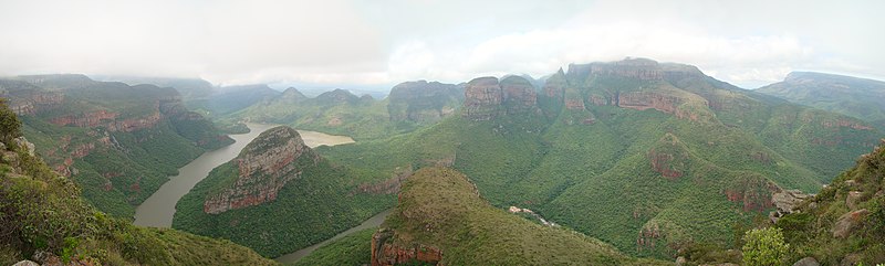
| Description | English: A panorama view towards north/west from Blyde River Canyon viewpoint. The almost free-standing peaks to the right of the center of the photo are called The Three Rondavels, named for their similarity of the traditional house of the region, the rondavel. The dam level is at about 700m a.s.l., while the peaks rise to 1,794m (Mogologolo on left) and 1,767m (Hebronberg on right). |
| Date | |
| Source | Own work by uploader, http://bjornfree.com/galleries.html |
| Author | Bjørn Christian Tørrissen |
| Camera location | | View this and other nearby images on: OpenStreetMap |
|---|
Licensing
I, the copyright holder of this work, hereby publish it under the following licenses:
This file is licensed under the Creative Commons Attribution-Share Alike 3.0 Unported license.
- You are free:
- to share – to copy, distribute and transmit the work
- to remix – to adapt the work
- Under the following conditions:
- attribution – You must give appropriate credit, provide a link to the license, and indicate if changes were made. You may do so in any reasonable manner, but not in any way that suggests the licensor endorses you or your use.
- share alike – If you remix, transform, or build upon the material, you must distribute your contributions under the same or compatible license as the original.

|
Permission is granted to copy, distribute and/or modify this document under the terms of the GNU Free Documentation License, Version 1.2 or any later version published by the Free Software Foundation; with no Invariant Sections, no Front-Cover Texts, and no Back-Cover Texts. A copy of the license is included in the section entitled GNU Free Documentation License. |
You may select the license of your choice.
| Annotations | This image is annotated: View the annotations at Commons |
File history
Click on a date/time to view the file as it appeared at that time.
| Date/Time | Thumbnail | Dimensions | User | Comment | |
|---|---|---|---|---|---|
| current | 21:20, 19 March 2011 | 10,382 × 3,125 (10.46 MB) | Uspn | {{Information |Description ={{en|1=A panorama view towards north/west from Blyde River Canyon viewpoint. The almost free-standing peaks to the right of the center of the photo are called The Three Rondavels, named for their similarity of the traditiona |
File usage
The following 3 pages use this file:
Global file usage
The following other wikis use this file:
- Usage on fr.wikipedia.org
- Usage on he.wikipedia.org