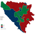
File:BeforeDayton.png

Size of this preview: 619 × 599 pixels. Other resolutions: 248 × 240 pixels | 496 × 480 pixels | 793 × 768 pixels | 1,057 × 1,024 pixels | 1,809 × 1,752 pixels.
Original file (1,809 × 1,752 pixels, file size: 160 KB, MIME type: image/png)
File history
Click on a date/time to view the file as it appeared at that time.
| Date/Time | Thumbnail | Dimensions | User | Comment | |
|---|---|---|---|---|---|
| current | 11:52, 27 September 2024 |  | 1,809 × 1,752 (160 KB) | Ceha | Brčko |
| 11:40, 27 September 2024 |  | 1,809 × 1,752 (160 KB) | Ceha | Oko Brčkog | |
| 11:31, 27 September 2024 |  | 1,809 × 1,752 (161 KB) | Ceha | Drežnica | |
| 12:57, 13 February 2022 |  | 1,809 × 1,752 (161 KB) | Ceha | Brčko | |
| 23:37, 24 January 2022 |  | 1,809 × 1,752 (161 KB) | Ceha | Žepče | |
| 23:29, 24 January 2022 |  | 1,809 × 1,752 (161 KB) | Ceha | Jugoistočno Brčko | |
| 14:56, 23 January 2022 |  | 1,809 × 1,752 (161 KB) | Ceha | Oko Bihaća | |
| 02:37, 14 March 2020 |  | 1,809 × 1,752 (161 KB) | Ceha | *Southern and western pockets around Bihać (Lika Villages and beyond Una) *eastern borders of Bočac and Banja Luka and Kneževo villages under HVO control | |
| 14:22, 19 May 2017 |  | 1,809 × 1,752 (160 KB) | Ceha | Uskoplje, Rama | |
| 14:16, 19 May 2017 |  | 1,809 × 1,752 (160 KB) | Ceha | HV also conquered Bočac |
File usage
The following 5 pages use this file:
Global file usage
The following other wikis use this file:
- Usage on an.wikipedia.org
- Usage on ar.wikipedia.org
- Usage on azb.wikipedia.org
- Usage on bs.wikipedia.org
- Usage on cs.wikipedia.org
- Usage on da.wikipedia.org
- Usage on es.wikipedia.org
- Usage on et.wikipedia.org
- Usage on fa.wikipedia.org
- Usage on fi.wikipedia.org
- Usage on fr.wikipedia.org
- Usage on hr.wikipedia.org
- Usage on hu.wikipedia.org
- Usage on id.wikipedia.org
- Usage on ko.wikipedia.org
- Usage on mk.wikipedia.org
- Usage on ms.wikipedia.org
- Usage on pt.wikipedia.org
- Usage on ru.wikipedia.org
- Usage on sh.wikipedia.org
- Usage on sr.wikipedia.org
- Usage on tr.wikipedia.org
- Usage on uk.wikipedia.org

