
File:Banat Josephinische Landaufnahme pg031.jpg

Size of this preview: 800 × 546 pixels. Other resolutions: 320 × 218 pixels | 640 × 437 pixels | 1,024 × 699 pixels | 1,280 × 874 pixels | 2,560 × 1,748 pixels | 8,360 × 5,708 pixels.
Original file (8,360 × 5,708 pixels, file size: 29.85 MB, MIME type: image/jpeg)
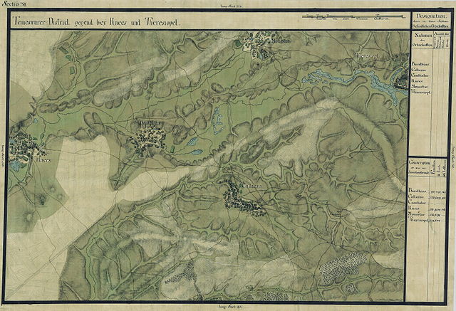
| Name shown on the map Nume din hartă |
Administrative unit Unitate administrativă |
Romanian name Numele românesc |
Hungarian name Numele unguresc |
German name Numele german |
Serbian name Numele sârbesc |
Country today Ţara de astăzi |
|---|---|---|---|---|---|---|
| Barathias | Temes megye Komitat Temes Comitatul Timiş |
Bărăteaz | Baracháza | Baratzhausen, Berndjas | Беретеаз | Románia |
| Callazzo | Temes megye | Călacea | Temeskalácsa | Kalatscha | Románia | |
| Cambiatur | Temes megye | Orţişoara | Kokota, Orczyfalva | Orzydorf, Orzidorf, Orczydorf | Románia | |
| Knees | Temes megye | Satchinez | Temeskenéz, Kenéz, Knéz | Knees, Knes | Општина Кнез | Románia |
| Monostur | Temes megye | Mănăştur | Monostor | Manester | Моноштор | Románia |
| Theresiopolis | Temes megye | Vinga | Vinga, Veresvinga, Kerekvinga | Winga, Theresiopel | Винга | Romania |
Summary
| Description | Deutsch: Das Banat in: Josephinische Landesaufnahme, 1769-72. Josephinische Landaufnahme pg031 English: The Banat region in the cadastral maps: Josephinische Landesaufnahme, 1769-72. Josephinische Landaufnahme pg031 |
||||
| Date | between 1769 and 1772 | ||||
| Source | Österreichisches Staatsarchiv, Kriegsarchiv | ||||
| Author | Historische Militärkarte der österreichisch-ungarischen Monarchie | ||||
| Permission (Reusing this file) |
|
||||
Clickable map of the Banat region

File history
Click on a date/time to view the file as it appeared at that time.
| Date/Time | Thumbnail | Dimensions | User | Comment | |
|---|---|---|---|---|---|
| current | 08:11, 2 January 2010 | | 8,360 × 5,708 (29.85 MB) | Asybaris01 | {{Information |Description={{ro|1=Banat Josephinische Landaufnahme pg031}} |Source={{own}} |Author=Asybaris01 |Date=1769-72 |Permission= |other_versions= }} Category:Josephinische Landaufnahme |
File usage
Global file usage
The following other wikis use this file:
- Usage on arz.wikipedia.org
- Usage on de.wikipedia.org
- Usage on es.wikipedia.org
- Usage on hu.wikipedia.org
- Usage on ro.wikipedia.org