Langbahn Team – Weltmeisterschaft

File:2024-uk-election-by-region-and-nation-full.svg

Original file (SVG file, nominally 1,312 × 1,157 pixels, file size: 2.31 MB)

Summary

Description
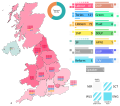
English: The map shows the results of the election in the nine regions of England, as well as the nations of Scotland, Wales and Northern Ireland. The subdivisions are shaded according to the percentage of seats secured by the strongest party in that subdivision. To the right of the map there is a small bar chart showing the turnout, as well as a large legend detailing parties, their results as well as colors used for shading the map. Each party - except for the Speaker, who is a single individual - has four colored, striped or grey squares next to it. The squares denote each of the UK's four nations. Clockwise from the top right there are Scotland (SCT), England (ENG), Wales (WLs) and Northern Ireland (NIR). A colored square denotes that a party stood for the election in that nation and won at least one seat: a striped square denotes that it stood, but did not win a single seat, while a grey square denotes that it did not stand. The outlines of the regions and nations are taken from File:2019 UK general election, countries and regions.svg
Date
Source Own work
Author MapperGuy87

Licensing

I, the copyright holder of this work, hereby publish it under the following license:
Creative Commons CC-Zero This file is made available under the Creative Commons CC0 1.0 Universal Public Domain Dedication.
The person who associated a work with this deed has dedicated the work to the public domain by waiving all of their rights to the work worldwide under copyright law, including all related and neighboring rights, to the extent allowed by law. You can copy, modify, distribute and perform the work, even for commercial purposes, all without asking permission.

Captions

The results of the 2024 UK general election by region and nation

Items portrayed in this file

depicts

creator

some value

author name string: MapperGuy87
Wikimedia username: MapperGuy87

copyright status

copyrighted, dedicated to the public domain by copyright holder

copyright license

Creative Commons CC0 License

source of file

original creation by uploader

inception

6 July 2024

media type

image/svg+xml

data size

2,421,325 byte

checksum

8a830131d0b02c0b4b163c5cccc3c53975d70ea6

determination method or standard: SHA-1

File history

Click on a date/time to view the file as it appeared at that time.

Date/TimeThumbnailDimensionsUserComment
current09:54, 11 July 2024Thumbnail for version as of 09:54, 11 July 20241,312 × 1,157 (2.31 MB)MapperGuy87Changed the Plaid's color to a shade of green to be consistent with the Wales map.
15:28, 8 July 2024Thumbnail for version as of 15:28, 8 July 20241,312 × 1,157 (2.31 MB)MapperGuy87Changed the UUP's color to a darker shade of blue, corrected a typo where the TUV was called the TUP.
21:46, 6 July 2024Thumbnail for version as of 21:46, 6 July 20241,312 × 1,157 (2.31 MB)MapperGuy87Fixed an error where the Greens were shown to win at least one seat in Wales.
15:33, 6 July 2024Thumbnail for version as of 15:33, 6 July 20241,312 × 1,157 (2.31 MB)MapperGuy87Uploaded own work with UploadWizard

The following 2 pages use this file:

Global file usage

The following other wikis use this file:

Metadata