Fale, Tuvalu
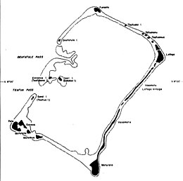
 Map of Nukufetau with Fale on the bottom left | |
| Geography | |
|---|---|
| Coordinates | 8°02′S 178°18′E / 8.033°S 178.300°E |
| Administration | |
| Atoll | Nukufetau |
Fale is an islet of Nukufetau, Tuvalu.[1][2] The traditional history of Nukufetau recalls that in order to protect the atoll from raiders from Tonga, Lagitupu and Laupapa, two aliki (chiefs) protected Fale.[3] Lagitupu and Laupapa created a trap at a place still called Tututekolo, which was beside a path which led to the beach, where they would surprise the raiders and spear them or split their skulls with an axe made from shells.[3]
In the late 19th century, after the coming of the missionaries, the people of Nukufetau lived on Fale before shifting to Savave, an islet on the lagoon side of the Fale and Laupapa settlement.[3]
Historic grave sites have been found on Fale.[4]
Food is grown on Fale, supplying to the main village on neighbouring Savave. The main products are pulaka (a root crop) and pigs.[5]
References
- ^ Map of Nukufetau Atoll. Tuvaluislands.com. Archived from the original on February 29, 2008.
{{cite book}}: CS1 maint: unfit URL (link) - ^ British Admiralty Nautical Chart 766 Ellice Islands (1893 ed.). United Kingdom Hydrographic Office (UKHO). 21 March 1872.
- ^ a b c Lafita, Nofoaiga (1983). "Chapter 12 – Nukufetau". In Laracy, Hugh (ed.). Tuvalu: A History. Institute of Pacific Studies, University of the South Pacific and Government of Tuvalu. pp. 86–87.
- ^ Taafaki, Pasoni (1983). "Chapter 2 – The Old Order". In Laracy, Hugh (ed.). Tuvalu: A History. Institute of Pacific Studies, University of the South Pacific and Government of Tuvalu. p. 26.
- ^ "Food Production on Funaota Islet, Tuvalu" (PDF). Live & Learn Environmental Education. March 2020. p. 4.

