Erco (river)
| Erco | |
|---|---|
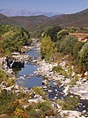
 Fishing for trout in the Erco | |
| Native name | Ercu (Corsican) |
| Location | |
| Country | France |
| Region | Corsica |
| Department | Haute-Corse |
| Physical characteristics | |
| Mouth | Golo |
• coordinates | 42°20′32″N 9°02′12″E / 42.3422°N 9.0367°E |
| Basin features | |
| Progression | Golo→ Tyrrhenian Sea |
The Erco (Corsican: Ercu) is a stream in the department of Haute-Corse, Corsica, France. It is a tributary of the Golo.
Course
The Erco is 11.18 kilometres (6.95 mi) long. It crosses the communes of Calacuccia, Corscia and Lozzi.[1] The stream originates in the commune of Lozzi to the south of the 2,706 metres (8,878 ft) Monte Cinto. It flows in a generally southeast direction to its confluence with the Golo between Calacuccia and Corscia. The D84 road crosses the Erco just above its mouth, but otherwise there are no roads along its course.[2]
Hydrology
Measurements of the stream flow were taken at the Calacuccia [Cuccia] station from 1979 to 1993. The watershed above this station covers 23 square kilometres (8.9 sq mi). Annual precipitation was calculated as 1,117 millimetres (44.0 in). The average flow of water throughout the year was 0.813 cubic metres per second (28.7 cu ft/s).[3]
| Month | Flow |
|---|---|
| Jan | |
| Feb | |
| Mar | |
| Apr | |
| May | |
| Jun | |
| Jul | |
| Aug | |
| Sep | |
| Oct | |
| Nov | |
| Dec |
Tributaries
The following streams (ruisseaux) are tributaries of the Erco:
- Forcu Ario 3 km (1.9 mi)
- Cappiaghia 3 km (1.9 mi)
- Pulella 2 km (1.2 mi)
- Tileri 2 km (1.2 mi)
- Travizzolu 2 km (1.2 mi)
- Forcioli 2 km (1.2 mi)
- Monte Cinto 2 km (1.2 mi)
- Osu 1 km (0.62 mi)
- Alzi Mozzi 1 km (0.62 mi)
Notes
Sources
- "L'Erco à Calacuccia [Cuccia]", eaufrance (in French), Ministère de l'Ecologie, du Développement Durable et de l'Energie, retrieved 2021-12-21
- "Relation: Ruisseau d'Erco (9104309)", OpenStreetMap, retrieved 2021-12-21
- "Ruisseau d'Erco", Sandre (in French), retrieved 2021-12-21


