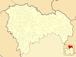
El Casar
El Casar | |
|---|---|
 | |
 | |
| Coordinates: 40°42′12″N 3°25′35″W / 40.70333°N 3.42639°W | |
| Country | Spain |
| Region | Castile-La Mancha |
| Province | Guadalajara |
| Area | |
• Total | 51.84 km2 (20.02 sq mi) |
| Elevation | 833 m (2,733 ft) |
| Population (2018)[1] | |
• Total | 11,812 |
| • Density | 230/km2 (590/sq mi) |
| Time zone | UTC+1 (CET) |
| • Summer (DST) | UTC+2 (CEST) |
El Casar (Spanish pronunciation: [el kaˈsaɾ]) is a municipality located in the province of Guadalajara, Castile-La Mancha, Spain.
Located in the border with the Community of Madrid, in the route of the N-320 road,[2] it lies at 833 metres above sea level.[3] The municipality covers an area of 51.84 km2.[4]
As of 2018 it has a population of 11,812. El Casar is one of the municipalities in the province that experienced a great population increase in the late 20th century,[5] in parallel to a huge increase in the urbanised area, through low-density residential developments, initially intended mainly for second homes.[2] The population has roughly multiplied tenfold during the 1981–2011 period.[6]
References
- ^ Municipal Register of Spain 2018. National Statistics Institute.
- ^ a b Santiago Rodríguez, Eduardo de (2008). "Madrid "ciudad única" (II). La explosión urbana en la región madrileña y sus efectos colaterales". Urban 13 (in Spanish) (13): 153. ISSN 1138-0810.
- ^ "Predicción por municipios. Casar, El (Guadalajara)". AEMET.
- ^ "Municipios". Datos del Registro de Entidades Locales. Ministerio de Hacienda y Administraciones Públicas.
- ^ Pozo Rivera, Enrique; Rodríguez Moya, Juana (2006). "Transformaciones sociodemográficas recientes en las comarcas Castellano Manchegas limítrofes con la Comunidad de Madrid". Anales de Geografía (26). Universidad Complutense de Madrid: 249–281. ISSN 0211-9803.
- ^ "Alteraciones de los municipios en los Censos de Población desde 1842". Instituto Nacional de Estadística.


