Effects of Hurricane Floyd in North Carolina
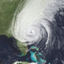
 Floyd on September 15 as a Category 3 hurricane nearing North Carolina | |
| Meteorological history | |
|---|---|
| Duration | September 15–16, 1999 |
| Category 2 hurricane | |
| 1-minute sustained (SSHWS/NWS) | |
| Highest winds | 100 mph (155 km/h) |
| Overall effects | |
| Fatalities | 52 |
| Damage | $3 billion (1999 USD) |
| Areas affected | Eastern North Carolina |
Part of the 1999 Atlantic hurricane season | |
| Effects
Other wikis | |
The effects of Hurricane Floyd in North Carolina was the costliest natural disaster in the state's history until it was surpassed by Hurricane Florence in 2018, and later by Hurricane Helene in 2024.
After the storm, the name Floyd was retired and removed from the Atlantic hurricane naming list. The United States government provided North Carolina with over $277 million in disaster related assistance.
Preparations
Hurricane Floyd was a long-tracked Cape Verde hurricane that threatened to strike Florida for several days, until a turn toward the north occurred. As Floyd turned away from Florida, the National Hurricane Center (NHC) issued various tropical cyclone warnings and watches for the East Coast of the United States. Late on September 14, the agency issued a hurricane watch for the North Carolina coast, which included the Pamlico and Albemarle sounds. The watch was upgraded to a hurricane warning six hours later. The warning was discontinued on September 16 after Floyd exited the region.[1] Local Weather Forecast Offices in Raleigh, Wilmington, and Morehead City North Carolina, as well as Wakefield, Virginia, issued various flood, flash flood, river, and tornado warnings. The local weather forecast office warned of flooding along the Neuse River 201 hours in advance of the river crest.[2]
Officials opened at least 40 emergency shelters in North Carolina.[3]
Impact

Hurricane Floyd left more than $3 billion in damage in North Carolina.[4] This made Floyd the costliest hurricane in North Carolina's history. It retained this status until 2018, when Hurricane Florence left $22 billion in damage in the state.[5] With 76 fatalities reported nationwide, Floyd was the deadliest hurricane in the United States since Hurricane Agnes in 1972; 52 of these fatalities occurred in North Carolina.[6] Of the 52 statewide deaths, at least 23 were near or in flooded vehicles, 6 drowned in a capsized boat, and 1 was a fatal car accident.[2] Throughout the state, the hurricane left 500,000 people without electricity. Floyd damaged 56,000 homes statewide, with 17,000 homes left uninhabitable, and another 7,000 homes destroyed.[4] The rains flooded most roads east of Interstate 95, and more than 1,500 people required rescue from their flooded homes.[4]
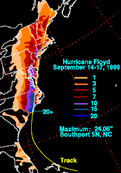
Hurricane Floyd affected North Carolina less than two weeks after Tropical Storm Dennis moved through the state and saturated grounds.[7] The interaction between Floyd and a cold front dropped torrential rainfall across the eastern United States, with the heaviest totals along the storm's path.[1] A pluviometer north of Southport recorded 24.06 in (611 mm) of rainfall during the storm, the highest rainfall total in the country associated with Floyd.[8] Much of east-central North Carolina received more than 12 in (300 mm) of precipitation, with a 24-hour total of 15.06 in (383 mm) recorded in Wilmington, breaking the 128 year record.[1] Kinston recorded 13.98 in (355 mm) of precipitation during the storm, and Rocky Mount reported 18.0 in (460 mm) of rainfall; both totals were greater than the expected 100 year storm.[7][9]
The heavy rains collected in rivers and streams, causing record flooding along the Cape Fear, Chowan, Neuse, Pee Dee, Tar, and Waccaaw rivers. Water gauges at 39 locations reached record levels in the state. Along all of the states' river basins east of Raleigh, stations recorded 500 year floods, and some locations remained flooded for two months. The most significant flooding occurred along the Tar River at Tarboro, more than 10 ft (3.0 m) higher than the previous record set in 1940. When a river gauge on the Tar near Greenville malfunctioned, a National Weather Service employee took manual observations every hour to document the record flood. The Neuse River at Goldsboro crested at 28.85 ft (8.79 m), breaking the record set after Hurricane Fran in 1996.[2][7][9] Much of Duplin and Greene counties were under water.[3] Some rivers remained above flood stage for over a month, as additional rainfall from Hurricane Irene in October would again raise water levels soon after Floyd.[7]
When Floyd made landfall on North Carolina, the NHC estimated maximum sustained winds of around 105 mph (169 km/h). The highest reported sustained wind was 64 mph (103 km/h) at Marine Corps Air Station Cherry Point. Wind gusts were much higher, reaching 138 mph (222 km/h) in Wrightsville Beach, at the elevation of an eight–story building. Other strong wind gusts included 122 mph (196 km/h) at Topsail Beach, and 120 mph (190 km/h) at the Wilmington Emergency Operations Center.[1] The National Weather Service issued 20 tornado warnings for the state.[3] Floyd spawned at least 16 tornadoes across eastern North Carolina. Ten of these occurred in the Wilmington area. In Perquimans County, a tornado destroyed two houses and damaged two others.[1]

Along the Atlantic Coast, Albemarle Sound, and river basins, Floyd produced a significant storm tide. The highest water level in the state was 10.3 ft (3.1 m) on Masonboro Island.[1] The hurricane caused significant beach erosion along south-facing beaches. Pine Knoll Shores lost about 50 ft (15 m) of sand. Two coastal piers lost significant sections from the waves. On Ocracoke Island, high tides washed away dunes at ten locations.[3] On Oak and Topsail Islands, the high waters damaged homes.[10]
Aftermath
On September 16, 1999, then-President Bill Clinton declared an emergency for 66 counties in eastern North Carolina, as requested by Jim Hunt, the state's governor at the time. The declaration authorized Federal Emergency Management Agency (FEMA) to provide resources and personnel, funding for 75% of the cost of debris removal, and loans from the Small Business Administration.[11][12] Within a week of the declaration, more than 36,000 state residents applied for some form of disaster assistance, mostly for housing or unemployment. FEMA opened 16 disaster recovery centers and a mobile office to assist residents with the application process.[13] In the immediate aftermath of the storm, FEMA spent more than $25.8 million in emergency spending for other agencies, including rescue efforts, sheltering, supplying water, ice, generators, plastic sheeting, and other emergency materials.[14] The federal government deployed 797 employees to North Carolina, including more than 400 housing inspectors.[13]
The federal application period ended on February 29, 2000, by which time more than 88,500 state residents had applied for aid. By a year after Floyd struck North Carolina, the state and federal government had provided $1.9 billion worth of assistance. The largest assistance program was $503 million in low-interest loans from the Small Business Administration, for 12,863 renters, homeowners, and business owners. State and federal resources provided $306.5 million in direct housing assistance. The National Flood Insurance Program paid more than $143 million to 12,843 residents who lost their properties due to floods. For uninsured residents who did not qualify for loans, FEMA provided $92.1 million to 23,873 households in grants. FEMA also provided 2,535 trailers for displaced residents, at the cost of $48 million. The federal government authorized $133.1 million to cover 75% of the cost of repairing and rebuilding public facilities. The Hazard Mitigation Grant Program spent $149.1 million to purchase 2,074 flooded homes and tear them down, preserving the land instead as green space. At the time, it was the largest building buyout program in American history.[14]
See also
References
- ^ a b c d e f Richard J. Pasch; Todd B. Kimberlain; Stacy R. Stewart (September 9, 2014). Hurricane Floyd Preliminary Report (PDF) (Report). National Hurricane Center.
- ^ a b c Hurricane Floyd Floods of September 1999 (PDF) (Report). National Oceanic and Atmospheric Administration. June 2000. p. 8. Retrieved July 12, 2019.
- ^ a b c d "Hurricane (Typhoon) Event Report". National Climatic Data Center. Retrieved May 23, 2019.
- ^ a b c "Hurricane Floyd Floyd, September 1999". Raleigh, North Carolina National Weather Service. Retrieved May 14, 2019.
- ^ Gabe Ross (March 20, 2019). "World Meteorological Organization retires storm names Florence and Michael". WECT-6. Retrieved May 14, 2019.
- ^ Costliest U.S. tropical cyclones tables updated (PDF) (Report). Miami, Florida: National Hurricane Center. January 26, 2018. Retrieved January 29, 2018.
- ^ a b c d Two Months of Flooding in Eastern North Carolina, September - October 1999: Hydrologic Water-Quality, and Geologic Effects of Hurricanes Dennis, Floyd, and Irene (Report). Water-Resources Investigations Report. United States Geological Survey. 2000. Retrieved May 26, 2019.
- ^ Roth, David M. (January 3, 2023). "Tropical Cyclone Point Maxima". Tropical Cyclone Rainfall Data. United States Weather Prediction Center. Retrieved January 6, 2023.
 This article incorporates text from this source, which is in the public domain.
- ^ a b "Flooding". Two Months of Flooding in Eastern North Carolina, September - October 1999: Hydrologic Water-Quality, and Geologic Effects of Hurricanes Dennis, Floyd, and Irene (Report). Water-Resources Investigations Report. United States Geological Survey. 2000. Retrieved May 27, 2019.
- ^ "Shoreline Changes". Two Months of Flooding in Eastern North Carolina, September - October 1999: Hydrologic Water-Quality, and Geologic Effects of Hurricanes Dennis, Floyd, and Irene (Report). Water-Resources Investigations Report. United States Geological Survey. 2000. Retrieved May 26, 2019.
- ^ "Disaster Aid Ordered For North Carolina Hurricane Recovery". FEMA. September 15, 1999. Retrieved July 16, 2019.
- ^ "SBA Ready to Aid North Carolina Residents". FEMA. September 17, 1999. Retrieved July 19, 2019.
- ^ a b "Hurricane Floyd At A Glance". FEMA. September 26, 1999. Retrieved July 19, 2019.
- ^ a b "Nearly 500 FEMA Inspectors Checking Damaged Properties In North Carolina". FEMA. October 5, 1999. Retrieved July 19, 2019.
