Džbánov
Džbánov | |
|---|---|
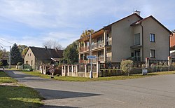
 Centre of Džbánov | |
| Coordinates: 49°54′59″N 16°9′34″E / 49.91639°N 16.15944°E | |
| Country | |
| Region | Pardubice |
| District | Ústí nad Orlicí |
| First mentioned | 1292 |
| Area | |
• Total | 6.59 km2 (2.54 sq mi) |
| Elevation | 294 m (965 ft) |
| Population (2024-01-01)[1] | |
• Total | 377 |
| • Density | 57/km2 (150/sq mi) |
| Time zone | UTC+1 (CET) |
| • Summer (DST) | UTC+2 (CEST) |
| Postal code | 566 01 |
| Website | www |
Džbánov is a municipality and village in Ústí nad Orlicí District in the Pardubice Region of the Czech Republic. It has about 400 inhabitants.
Etymology
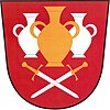
The similarity with the Czech word džbán (i.e. 'jug') is only coincidental. The name of the village probably originates in the personal name Čban that belonged to one of the first reeves or settlers. Later the village was called Čbánov and then Džbánov.[2]
Geography
Džbánov is located about 28 kilometres (17 mi) southeast of Pardubice. It lies in the Svitavy Uplands. The highest point is at 404 m (1,325 ft) above sea level.
History
Džbánov was founded in the mid-13th century. The first written mention of Džbánov is from 1292. In the 14th century, it was property of the Zbraslav Monastery. After the Hussite Wars, the village property was split between several placeholders (the emperor, the town of Vysoké Mýto, royal chamber, and the noble family of Kostka of Postupice). The town of Vysoké Mýto owned the whole village from the late 16th century to 1850. Afterwards the village became autonomous municipality.[2]
Demographics
|
|
| ||||||||||||||||||||||||||||||||||||||||||||||||||||||
| Source: Censuses[3][4] | ||||||||||||||||||||||||||||||||||||||||||||||||||||||||
Transport
Džbánov is located on the railway line Litomyšl–Choceň.[5]
Sights
Džbánov is poor in monuments. The only protected cultural monument is the rural homestead No. 17 from the early 19th century.[6]
References
- ^ "Population of Municipalities – 1 January 2024". Czech Statistical Office. 17 May 2024.
- ^ a b "Historie" (in Czech). Obec Džbánov. Retrieved 13 June 2022.
- ^ "Historický lexikon obcí České republiky 1869–2011" (in Czech). Czech Statistical Office. 21 December 2015.
- ^ "Population Census 2021: Population by sex". Public Database. Czech Statistical Office. 27 March 2021.
- ^ "Detail stanice Džbánov" (in Czech). České dráhy. Retrieved 20 June 2024.
- ^ "Výsledky vyhledávání: Kulturní památky, obec Džbánov". Ústřední seznam kulturních památek (in Czech). National Heritage Institute. Retrieved 28 June 2023.


