Cha-am district
Cha-am ชะอำ | |
|---|---|
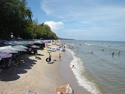
 Cha-am Beach | |
 District location in Phetchaburi province | |
| Coordinates: 12°47′59″N 99°58′1″E / 12.79972°N 99.96694°E | |
| Country | Thailand |
| Province | Phetchaburi |
| Seat | Cha-am |
| Subdistricts | 9 |
| Area | |
• Total | 660.65 km2 (255.08 sq mi) |
| Population (2021) | |
• Total | 81,541 |
| • Density | 123.43/km2 (319.7/sq mi) |
| Time zone | UTC+7 (ICT) |
| Postal code | 76120 |
| Geocode | 7604 |
Cha-am[1] (Thai: ชะอำ, pronounced [tɕʰáʔām] or [tɕʰāʔām]) is a district (amphoe) in the southern part of Phetchaburi province, western Thailand.[2]
The district was established in 1897 with the name Na Yang. In 1914 the centre of the district was moved to Ban Nong Chok (now in Tha Yang district and its name was changed to Nong Chok. After World War II, the government moved the office to tambon Cha-am and also changed the district name to Cha-am.
Mrigadayavan Palace (Thai: พระราชนิเวศน์มฤคทายวัน, RTGS: Phra Ratchaniwet Maruekkhathayawan) in Cha-am district is a former residence of King Vajiravudh or Rama VI who ruled Siam from 1910 to 1925.
Toponymy
Its name "Cha-am" is said to have originated from the word "Cha-an" (ชะอาน, pronounced [tɕʰáʔān] or [tɕāʔāːn]) meaning "to wash the saddle". In the Ayutthaya period, Viceroy Ekathotsarot (later King Ekathotsarot) raised an army to fight against the Burmese in this area, and washed his saddle here. Hence the name "Cha-an" and was distorted into "Cha-am" like today[3]
Location
Cha-am lies 173 km (107 mi) south of Bangkok on Phet Kasem Road. Just a few trains stop at the town's railway station. Frequent bus and minibus services link Cha-am with neighbouring towns, such as Hua Hin, and with Bangkok. The district to the north is Tha Yang district. 27 km (17 mi) to the south is Hua Hin district of Prachuap Khiri Khan province, also a beach resort.
Administration
Cha-am district is divided into nine sub-districts (tambons).
| 1. | Cha-am | ชะอำ | |
| 2. | Bang Kao | บางเก่า | |
| 3. | Na Yang | นายาง | |
| 4. | Khao Yai | เขาใหญ่ | |
| 5. | Nong Sala | หนองศาลา | |
| 6. | Huai Sai Nuea | ห้วยทรายเหนือ | |
| 7. | Rai Mai Phatthana | ไร่ใหม่พัฒนา | |
| 8. | Sam Phraya | สามพระยา | |
| 9. | Don Khun Huai | ดอนขุนห้วย |
Economy

Tourism plays a significant role in the economy of Cha-am and Phetchaburi Province. The province, however, has dropped from the fourth to the sixth most popular destination in Thailand due to coastal erosion, much of it in Cha-am, caused by rising sea levels leading to "deteriorating scenery".[4]
Education
Several tertiary educational institutions and universities are in Cha-am and surrounding districts including Silpakorn University (Phetchaburi IT Campus), Suan Dusit Rajaphat University, Stamford International University, and Webster University Thailand.
References
- ^ ประกาศราชบัณฑิตยสถาน เรื่อง การเขียนชื่อจังหวัด เขต อำเภอ และกิ่งอำเภอ (PDF). Royal Gazette (in Thai). 117 (พิเศษ 94 ง): 2. 14 Sep 2000. Archived from the original (PDF) on January 25, 2012.
- ^ "About Cha-am". Tourism Authority of Thailand (TAT). Archived from the original on 22 April 2019. Retrieved 26 December 2017.
- ^ Nice To Meet You (2023-04-22). "ชะอำ" [Cha-am]. Thai PBS (in Thai). Retrieved 2023-04-23.
- ^ Arunmas, Phusadee; Apisitniran, Lamonphet; Kasemsuk, Narumon (13 January 2020). "Falling water levels deliver a taste of things to come". Bangkok Post. Retrieved 5 February 2020.
External links
 Cha-am travel guide from Wikivoyage
