Bunne
Bunne | |
|---|---|
Village | |
 Entrance to Bunne from the Eelderweg. (2011) | |
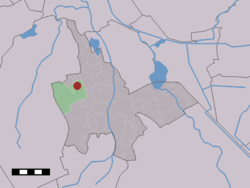
 The village (dark red) and the statistical district (light green) of Bunne in the municipality of Tynaarlo. | |
| Coordinates: 53°7′3″N 6°31′59″E / 53.11750°N 6.53306°E | |
| Country | Netherlands |
| Province | Drenthe |
| Municipality | Tynaarlo |
| Area | |
• Total | 12.93 km2 (4.99 sq mi) |
| Elevation | 5 m (16 ft) |
| Population (2021)[1] | |
• Total | 235 |
| • Density | 18/km2 (47/sq mi) |
| Time zone | UTC+1 (CET) |
| • Summer (DST) | UTC+2 (CEST) |
| Postal code | 9496[1] |
| Dialing code | 0591 |
Bunne is a village in the Dutch province of Drenthe. It is a part of the municipality of Tynaarlo, and lies about 11 km south of Groningen.
History
The village was first mentioned in 1206 or 1207 as Bonne. It could either mean "settlement of Bunne (person) or "settlement on a height".[3] Bunne developed as an esdorp. There used to be a small nun monastery in the village called "Het Huys van Bunne".[4]
Bunne was home to 110 people in 1840. In 1896, a cooperative dairy factory opened in the village. It closed in 1968, and was converted into a metal construction company in 1971. The chimney was demolished in 1980.[4]
Notable people
- Jan Aling (1949-2020), racing cyclist
Gallery
- Dairy factory
- Back road in Bunne
References
- ^ a b c "Kerncijfers wijken en buurten 2021". Central Bureau of Statistics. Retrieved 11 April 2022.
two entries
- ^ "Postcodetool for 9496PA". Actueel Hoogtebestand Nederland (in Dutch). Het Waterschapshuis. Retrieved 11 April 2022.
- ^ "Bunne - (geografische naam)". Etymologiebank (in Dutch). Retrieved 11 April 2022.
Authenticity of the 1143 reference is in doubt
- ^ a b "Bunne". Plaatsengids (in Dutch). Retrieved 11 April 2022.


