Pukchang County
Pukch'ang County 북창군 | |
|---|---|
| Korean transcription(s) | |
| • Chosŏn'gŭl | 북창군 |
| • Hancha | 北倉郡 |
| • McCune-Reischauer | Pukch'ang-gun |
| • Revised Romanization | Bukchang-gun |
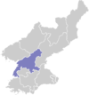
 Map of South Pyongan showing the location of Pukchang | |
| Country | North Korea |
| Province | South P'yŏngan |
| Administrative divisions | 1 ŭp, 4 workers' districts, 21 ri |
| Population (2008[1]) | |
• Total | 139,498 |
Pukch'ang County is a kun (county) in South P'yŏngan province, North Korea.
History
In 1952, Pukchang County was formed from the former area of Maengsan County and Tokchon. Since then, the county has been changed multiple times by merging in or transferring out some areas.[2]
In January 2000, Tukchang district was abolished and transferred to Pukchang County.[2] However, the district reappeared in the 2008 North Korea Census.
Environment
Pukchang County is located in a mountainous area. On the northern border with Tokchon runs the east-west Jangan mountain range. On the southern border with Unsan County, South Pyongan, the Chonsong mountain range also runs east-west. In the west of the county is the Mount Myohyang range. Around 80% of the county is forest.[3]
The Taedong River runs through the county.[3]
Administrative divisions
The district is split into 1 ŭp (town), 4 rodongjagu (worker districts) and 21 ri (villages):
|
|
|
Economy
Built in the 1960s with Soviet assistance,[4] Pukchang has the power station with the highest generating capacity in North Korea, with the Pukchang Thermal Power Complex having a generation capacity of 1600 MW, reached in December 1984.[5] According to official statistics in 2009, it generated on average 1100 MW throughout the year. Different estimates puts the generating capacity at only 500 MW. The power plant suffered issues due to the low quality fuel oil provided by the USA under the Agreed Framework, which had a high sulfur content and thus would cause significant damage to the boilers.[6] While an apparent replacement power plant with a capacity of 300 MW was being built in Kangdong County starting in 2014 due to aging of Pukchang Thermal Power Complex, the project appears to have stalled.[7] It draws water from the Taedong River.[8]
In December 12, 2018, an extension to the Pukchang Thermal Power Complex was inaugurated,[9] likely as a result of an order of Kim Jong-un, calling for a 'drastic increase in thermal power generation'. According to NKNews sources, various cities had a marked improvement in electricity supply in 2018, although rural areas mostly relied on solar panels.[10] The complex manufactures its own spare parts, such as turbine blades.[11]
The county has a large number of coal mines, producing high quality coal, which supports the thermal power complex. Various other light industry exist in the county along with a number of farms, producing vegetables and raising animals.[12]
The Pukchang Aluminum Factory, North Korea's only aluminum smelting and alloying plant has been condemned for releasing toxic dust over neighboring communities including offices, schools, homes, and businesses. The product of filters unreplaced since its construction in 1983, residents from the nearby community report high rates of birth defects, dermatitis, and respiratory disease contributing to an average life expectancy short of mid-50s. The "Class 1"-designated factory manufactures aluminum for North Korean missiles and centrifuges.[13]
Transport
The Pyongdok Line and Its branches, the Tukchang Line and Taegon Line passes through the county.
Roads connecting Pyongsong and Hamhung, Kumya and Pukchang, Tokchon and Pukchang run through the county.[14]
References
- ^ Korean Central Bureau of Statistics: 2008 Population Census Archived 2010-03-31 at the Wayback Machine (Population 2008, published in 2009)
- ^ a b "북한지역정보넷". www.cybernk.net. Retrieved 2021-09-17.
- ^ a b "북한지역정보넷". www.cybernk.net. Retrieved 2021-09-17.
- ^ http://www.kinu.or.kr/pyxis-api/1/digital-files/0b739cc6-96ee-42fe-a3a5-cefa4b43cd5c [bare URL PDF]
- ^ "Energy and Power - North Korean Targets". nuke.fas.org. Retrieved 2021-09-17.
- ^ "Pyongyang's Perpetual Power Problems". 38 North. 2014-11-25. Retrieved 2021-09-17.
- ^ "Coal-fired power plant under construction in North Korea". Power Engineering International. 2014-11-26. Retrieved 2021-09-17.
- ^ "Taedong River" (PDF). Kyoto University: 1.
- ^ "Extension Project of Generating Equipment Inaugurated". KCNA Watch. Archived from the original on 2018-12-13. Retrieved 2021-09-17.
- ^ nknews (2018-12-14). "North Korea expands capacity at nation's biggest electric plant: KCTV | NK News". NK News - North Korea News. Retrieved 2021-09-17.
- ^ "《조선의 오늘》". dprktoday.com. Retrieved 2021-09-17.
- ^ "북한지역정보넷". www.cybernk.net. Retrieved 2021-09-17.
- ^ Jang, Seulkee (6 January 2022). "North Korean aluminum factory releases pollutants straight into the air". DailyNK.
- ^ "북한지역정보넷". www.cybernk.net. Retrieved 2021-09-17.
External links
- (in English) Map of Pyongan provinces Archived 2012-03-11 at the Wayback Machine
- (in Korean) Detailed map

