Brevard Fault

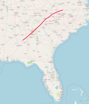
The Brevard Fault Zone is a 700-km[1] long and several km-wide thrust fault that extends from the North Carolina-Virginia border, runs through the north metro Atlanta area, and ends near Montgomery, Alabama. It is an important Paleozoic era feature in the uplift of the Appalachian Mountains.[2]
Discovery
Arthur Keith from the United States Geological Survey first identified an exposed segment of the Brevard Fault in 1905,[3] believing it to be a syncline. In 1932, Anna Jonas Stose’s used local petrology to identify the site as a thrust fault.[4] Stose, the first to trace the fault, is also credited with identifying that the rocks in the area must have been formed through deformation,[5] placing the Brevard Fault in a regional perspective.[3] Using modern methods of seismic reflection and high-resolution profiling, geologists have since discovered that the Brevard Fault Zone has undergone both thrust and strike-slip movement.[6]
Geology
The Brevard Fault Zone is a part of a much larger system of faults at the base of the Appalachian thrust sheet[1] that played a key role in uplifting the Appalachian Mountains. The extent of its role remains uncertain because most of the fault is buried beneath Quaternary sediment.[7] Many studies of the fault come from Grandfather Mountain in the Linville Fall Quadrangle,[8] which contains the exposed region that was first discovered by Arthur Keith. This region is only 1–3 km of its 700 km length.[7]
The Brevard Fault experienced multiple phases of deformation and minimal stratigraphic displacement.[3] The Brevard Fault Zone contains diverse lithologies, but it is primarily composed of mylonitic metagraywacke, schist, amphibolite, and gneiss[9] that underwent metamorphism 350–360 million years ago.[1] The Fault Zone is characterized by ductile behavior as indicated by the widespread presence of mylonitic and phyllonitic rocks.[1]
See also
Bibliography
- Robert D. Hatcher; Matthew T. Huebner; Justin R. Rehrer; Louis L. Acker; Paul D. Fullagar; Angang Liu; Patricia Lee Goad (11 September 2017). Geologic and kinematic insights from far-traveled horses in the Brevard fault zone, southern Appalachians. Vol. 213. doi:10.1130/2017.1213(13). ISBN 978-0-8137-8213-3. Wikidata Q61122687.
{{cite book}}:|journal=ignored (help) - Nikolas I. Christensen; Daniel L. Szymanski (1988). "Origin of reflections from the Brevard Fault Zone". Journal of Geophysical Research. 93 (B2): 1087. Bibcode:1988JGR....93.1087C. doi:10.1029/JB093IB02P01087. ISSN 0148-0227. Wikidata Q105127624.
- Thomas J. Crawford; Jack H. Medlin (1 October 1973). "The western Georgia Piedmont between the Cartersville and Brevard fault zones". American Journal of Science. 273 (8): 712–722. Bibcode:1973AmJS..273..712C. doi:10.2475/AJS.273.8.712. ISSN 0002-9599. Wikidata Q105128412.
References
- ^ a b c d Alain Vauchez (1987). "Brevard fault zone, southern Appalachians: A medium-angle, dextral, Alleghanian shear zone". Geology. 15 (7): 669. Bibcode:1987Geo....15..669V. doi:10.1130/0091-7613(1987)15<669:BFZSAA>2.0.CO;2. ISSN 0091-7613. Wikidata Q59666174.
- ^ Robert D. Hatcher (2001). "Rheological partitioning during multiple reactivation of the Palaeozoic Brevard Fault Zone, Southern Appalachians, USA". Geological Society, London, Special Publications. 186 (1): 257–271. Bibcode:2001GSLSP.186..257H. doi:10.1144/GSL.SP.2001.186.01.15. ISSN 0305-8719. Wikidata Q105126340.
- ^ a b c Bobyarchick, Andy (1999). "The history of investigation of the Brevard fault zone and evolving concepts in tectonics". Southeastern Geology. 38 (3): 223–238.
- ^ Dietrich, R. V. (1974). "Memorial to Anna I. Jonas Stose" (PDF). Geological Society of America. Archived (PDF) from the original on 2019-02-09.
- ^ Jonas, Anna Isabel (1932). "Structure of the metamorphic belt of the southern Appalachians". American Journal of Science. s5-24 (141): 228–243. doi:10.2475/ajs.s5-24.141.228. ISSN 0002-9599.
- ^ Gore, Pamela J. W.; Witherspoon, William D. (2013). Roadside Geology of Georgia. Missoula, Montana: Mountain Press Publishing Company. p. 187. ISBN 978-0-87842-602-7. OCLC 872634030.
- ^ a b Hatcher, Robert D.; Huebner, Matthew T.; Rehrer, Justin R.; Acker, Louis L.; Fullagar, Paul D.; Liu, Angang; Goad, Patricia Lee (2017). "Geologic and kinematic insights from far-traveled horses in the Brevard fault zone, southern Appalachians". Linkages and Feedbacks in Orogenic Systems: Geological Society of America Memoir. 213: 313–351. doi:10.1130/2017.1213(13). ISBN 9780813712130.
- ^ Reed, Jr., John C. (1964). "Geology of Linville Falls Quadrangle North Carolina" (PDF). Geological Survey Bulletin. 1161-B: B3.
- ^ "Mineral Resources Online Spatial Data". USGS. Archived from the original on 2018-06-25.
