Bocholtz
Bocholtz Bóches (Ripuarian) | |
|---|---|
Town | |
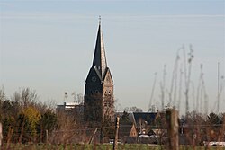
 The church in Bocholtz as seen from the Orsbacherweg | |
| Coordinates: 50°49′09″N 6°00′21″E / 50.8193°N 6.0057°E | |
| Country | Netherlands |
| Province | |
| Municipality | |
| Area | |
• Total | 9.30 km2 (3.59 sq mi) |
| Elevation | 25 m (82 ft) |
| Population (2021)[1] | |
• Total | 3,730 |
| • Density | 400/km2 (1,000/sq mi) |
| Time zone | UTC+1 (CET) |
| • Summer (DST) | UTC+2 (CEST) |
| Postal code | 6085[1] |
| Dialing code | 0475 |
Bocholtz (Dutch: [ˈbɔxɔlts]; Ripuarian: Bóches [ˈbʊχəs]) is a town in the Dutch province of Limburg. It is a part of the municipality of Simpelveld, and lies about 7 km southwest of Kerkrade. Until 1982, it was a separate municipality.
History
Bocholtz dates back to the Roman era. A Roman villa was found in the Vlengendaal, a street of Bocholtz, in 1911. A farmer plowing his land found a Roman sarcophagus in October 2003.[citation needed]
Architecture and buildings
Castle De Bongard
The Castle De Bongard dates from the 16th century. The current building only represents 1/4 of the original building. The rest was destroyed during the invasion by the French during the Napoleonic Wars.
Hoeve Overhuizen
Hoeve Overhuizen is a fortified farm with roots dating back as far as the 13th century.
In 2015, Rabobank moved in after redecorating the interior of the building to make it their regional headquarters.
Church
The James the Greater Church was built between 1869 and 1873 by architect Pierre Cuypers. Construction workers expanding the church in 1953 found the remains of a building from the late medieval period on the same site. The patron saint of the church is St. James, son of Zebedee.
Regional language
Bocholtz is part of the Netherlands and therefore the official language is Dutch. Many people also speak Bocholtzer, a Southeast Limburgish dialect that is linguistically Ripuarian but commonly perceived as a Limburgish dialect.
Gallery
- Castle De Bongard, Bocholtz
- Bocholtz in winter
- Location of the Roman villa Vlengendaal
- Former town hall
References
- ^ a b c "Kerncijfers wijken en buurten 2021". Central Bureau of Statistics. Retrieved 25 April 2022.
- ^ "Postcodetool for 6085AA". Actueel Hoogtebestand Nederland (in Dutch). Het Waterschapshuis. Retrieved 25 April 2022.


