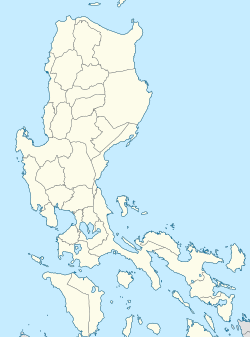
Binuangan, Obando
Binuangan | |
|---|---|
 View of the island barangay from Salambao | |
 | |
| Coordinates: 14°43′16″N 120°54′23″E / 14.72111°N 120.90639°E | |
| Country | |
| Region | Central Luzon |
| Province | Bulacan |
| Municipality | Obando |
| Government | |
| • Barangay Chairman | Jerry Silverio Mendoza |
| Population (2020) | |
• Total | 5,045 |
| ZIP code | 3021 |
| Area code | 44 |
Binuangan is a barangay in the coastal municipality of Obando in Bulacan, the Philippines. It is an island on an estuary formed by the confluence of Binuangan River and Muzon River along the coast of Manila Bay, north of Isla Pulo, Tanza, Navotas. The barangay is surrounded by intertidal mudflats and sandbars with fish pens separating it from the mainland of Obando to the east. It is bordered by the barangays of Tawiran and Paco on the north, Lawa to the east, Salambao on the south, and the Bulakan barangay of Taliptip to the west. As of the 2020 census, Binuangan had a population of 5,045.[1] Binuangan is an ancient barangay, mentioned in the earliest known document of the Philippines, the Laguna Copperplate Inscription in 900 AD.[2]
Gallery
See also
References
- ^ "Barangay Binuangan - Philippine Standard Geographic Code". Philippine Statistics Authority. Retrieved 2022-06-30.
- ^ Postma, Antoon (April–June 1992). "The Laguna Copper-Plate Inscription: Text and Commentary". Philippine Studies. 40 (2). Ateneo de Manila University: 182–203. JSTOR 42633308.
External links
 Media related to Binuangan, Obando, Bulacan at Wikimedia Commons


