Auflance
Auflance | |
|---|---|
 Ruins of the chateau | |
| Coordinates: 49°37′11″N 5°17′31″E / 49.6197°N 5.2919°E | |
| Country | France |
| Region | Grand Est |
| Department | Ardennes |
| Arrondissement | Sedan |
| Canton | Carignan |
| Intercommunality | CC Portes du Luxembourg |
| Government | |
| • Mayor (2020–2026) | Jean-Marie Turchi[1] |
Area 1 | 6.16 km2 (2.38 sq mi) |
| Population (2021)[2] | 83 |
| • Density | 13/km2 (35/sq mi) |
| Time zone | UTC+01:00 (CET) |
| • Summer (DST) | UTC+02:00 (CEST) |
| INSEE/Postal code | 08029 /08370 |
| Elevation | 176–281 m (577–922 ft) (avg. 193 m or 633 ft) |
| 1 French Land Register data, which excludes lakes, ponds, glaciers > 1 km2 (0.386 sq mi or 247 acres) and river estuaries. | |
Auflance is a commune in the Ardennes department and Grand Est region of north-eastern France.
Geography
Auflance is located on the frontier of Belgium along its eastern border some 38 km east by south-east of Sedan and 17 km north-west of Montmédy. Access to the commune is by the D17 road from Puilly-et-Charbeaux in the north-west which passes through the centre of the commune and the village and continues to Sapogne-sur-Marche in the south-east. A small country road crosses the Belgian border and goes to Villers-Devant-Orval. The commune is mixed forest and farmland.[3]
The Marche river forms the south-eastern border of the commune as it flows south-west to join the Chiers near Margut. The Paquis river passes through the centre of the commune from north-west to south-east where it joins the Marche on the border of the commune. The Coquerte flows from the north in the west to the commune to join the Paquis.[3]
Neighbouring communes and villages
Heraldry
 |
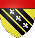
Blazon: Or, a bend of Sable charged with 3 Fleurs-de-lis Argent posed in bend côtoyée with 2 bendlets of Sable; in chief Gules.
|
Administration
List of Successive Mayors[4]
| From | To | Name |
|---|---|---|
| 2001 | 2014 | Michèle Delgoffe |
| 2014 | 2020 | Sabrina Thiébault |
| 2020 | current | Jean-Marie Turchi |
Demography
In 2017 the commune had 86 inhabitants.
|
| ||||||||||||||||||||||||||||||||||||||||||||||||||||||||||||||||||||||||||||||||||||||||||||||||||||||||||||
| Source: EHESS[5] and INSEE[6] | |||||||||||||||||||||||||||||||||||||||||||||||||||||||||||||||||||||||||||||||||||||||||||||||||||||||||||||

Sites and monuments


- The Chateau of Auflance (17th century)
 is registered as a historical monument.[7] In the 17th century the Custine family came to settle in this border commune. They built a castle of which only a few vestiges remain: a round tower, tunnels, and a remarkable Renaissance door decorated with coats of arms and surmounted by a Pietà.
 - In the Church the Funeral Chapel of the Custines has a hallway decorated with coats of arms which were made during the French Revolution
- The Saints of Auflance Chapel from the 13th century has 13 statues which have been stored out of fear of theft. These statues of the Saints of Auflance are registered as historical objects.
 [8]
[8]
See also
References
- ^ "Répertoire national des élus: les maires". data.gouv.fr, Plateforme ouverte des données publiques françaises (in French). 2 December 2020.
- ^ "Populations légales 2021" (in French). The National Institute of Statistics and Economic Studies. 28 December 2023.
- ^ a b c Google Maps
- ^ List of Mayors of France (in French)
- ^ Des villages de Cassini aux communes d'aujourd'hui: Commune data sheet Auflance, EHESS (in French).
- ^ Population en historique depuis 1968, INSEE
- ^ Ministry of Culture, Mérimée PA00078556 Chateau of Auflance (in French)
- ^ Ministry of Culture, Palissy PM08000031 13 Statues: Saints of Auflance (in French)

External links
- Auflance on the old IGN website (in French)
- Auflance on Géoportail, National Geographic Institute (IGN) website (in French)
- Aufflance on the 1750 Cassini Map


