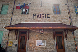
Arandas, Ain
Arandas | |
|---|---|
Commune | |
 Town hall | |
| Coordinates: 45°53′45″N 5°29′14″E / 45.8958°N 5.4872°E | |
| Country | France |
| Region | Auvergne-Rhône-Alpes |
| Department | Ain |
| Arrondissement | Belley |
| Canton | Ambérieu-en-Bugey |
| Intercommunality | La Plaine de l'Ain |
| Government | |
| • Mayor (2020–2026) | Lionel Manos[1] |
Area 1 | 14.10 km2 (5.44 sq mi) |
| Population (2021)[2] | 141 |
| • Density | 10/km2 (26/sq mi) |
| Time zone | UTC+01:00 (CET) |
| • Summer (DST) | UTC+02:00 (CEST) |
| INSEE/Postal code | 01013 /01230 |
| Elevation | 455–939 m (1,493–3,081 ft) (avg. 720 m or 2,360 ft) |
| 1 French Land Register data, which excludes lakes, ponds, glaciers > 1 km2 (0.386 sq mi or 247 acres) and river estuaries. | |
Arandas is a commune in the Ain department in the Auvergne-Rhône-Alpes region of eastern France.
The commune covers an area of 14.10 km² (5.44 sq mi). Lionel Manos is the mayor for the 2020-2026 tenure.
Geography
Arandas is some 50 km north-west of Aix-les-Bains and 10 km south-west of Hauteville-Lompnes. It can be accessed by the D104 from Argis in the north running south to the village then continuing south as the D104A through the heart of the commune to join the D32 south of the commune. The D104 itself reverses direction in the village and heads north-west to join the D73. The commune has some farmland but is heavily forested and mountainous. There are no villages or hamlets in the commune other than Arandas.[3]
The Bossiere stream rises near the village and flows west to join the Galine river. The Ruisseau de Grinand also rises in the north of the commune, forming part of the northern boundary before flowing into the Galine.[3]
History
In the Middle Ages Arandas was a lordship with the most famous lord being the poet Claude Guichard in the 16th century. The commune was separated from Conand in 1865.
Administration
The municipality of Arandas is a member of the Community of Communes of Plaine de l'Ain, a public inter-municipal cooperation establishment (EPCI) with its own taxation created on 15 December 2002, with its headquarters in Chazey-sur-Ain.[4]
Administratively, Arandas is part of the Arrondissement of Belley, the Ain department, and the Auvergne-Rhône-Alpes region.[5] In terms of electoral representation, it falls under the Ambérieu-en-Bugey canton for the election of departmental councilors, since the cantonal reorganization of 2014 came into effect in 2015,[6] and the fifth constituency of Ain for legislative elections, since the latest electoral division in 2010.[7]
Administration
| From | To | Name |
|---|---|---|
| 1995 | 2002 | Pierre Ronchall |
| 2002 | 2008 | Gilbert Cagnin |
| 2008 | 2014 | Gérard Duclaux |
| 2014 | Present | Jean-Marc Manos |
Population
| Year | Pop. | ±% p.a. |
|---|---|---|
| 1968 | 143 | — |
| 1975 | 140 | −0.30% |
| 1982 | 145 | +0.50% |
| 1990 | 128 | −1.55% |
| 1999 | 135 | +0.59% |
| 2007 | 158 | +1.99% |
| 2012 | 160 | +0.25% |
| 2017 | 144 | −2.09% |
| Source: INSEE[9] | ||
Personalities
- Anthelme Ferrand (1758-1834), politician, member of the Convention and the Council of Five Hundred was born in the commune.
See also
External links
- Arandas on the old National Geographic Institute website (in French)
- Arandas on Géoportail, National Geographic Institute (IGN) website (in French)
- Arandas on the 1750 Cassini Map
References
- ^ "Répertoire national des élus: les maires" (in French). data.gouv.fr, Plateforme ouverte des données publiques françaises. 13 September 2022. Archived from the original on 28 June 2020. Retrieved 22 November 2022.
- ^ "Populations légales 2021" (in French). The National Institute of Statistics and Economic Studies. 28 December 2023.
- ^ a b c Google Maps
- ^ "CC de la Plaine de l'Ain". BANATIC. Retrieved 14 October 2024.
- ^ "Commune d'Arandas (01013)". Retrieved 26 September 2024.
- ^ "Commune d'Arandas". archive.wikiwix.com. Archived from the original on 17 May 2023. Retrieved 17 May 2023.
- ^ "Les circonscriptions et cantons de l'Ain - Politiquemania". archive.wikiwix.com. Archived from the original on 17 May 2023. Retrieved 17 May 2023.
- ^ "MairesGenWeb". www.francegenweb.org (in French). Archived from the original on 22 November 2021. Retrieved 17 May 2023.
- ^ Population en historique depuis 1968 Archived 26 July 2022 at the Wayback Machine, INSEE


