West Yorkshire
| West Yorkshire | |
|---|---|
 | |
| Geografie | |
| Status: | Zeremonielle Grafschaft Metropolitan County |
| Region: | Yorkshire and the Humber |
| Fläche: | 2.209 km² |
| Demografie | |
| Einwohnerzahl: | 2.320.214 (2018) |
| Bevölkerungsdichte: | 1.050 Einwohner je km² |
| Metropolitan Boroughs | |
 | |
West Yorkshire ist ein Metropolitan County in England. Es entspricht in etwa dem Kern des West Riding der traditionellen Grafschaft Yorkshire. West Yorkshire grenzt an Lancashire, Greater Manchester, Derbyshire, North Yorkshire und South Yorkshire.
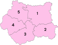
Das County besteht aus den fünf Metropolitan Boroughs Bradford, Calderdale, Kirklees, Leeds und Wakefield. Es wurde im Zuge der Kommunalreform 1974 gebildet; 1986 wurde die Grafschaftsverwaltung jedoch abgeschafft. Seitdem sind die Metropolitan Boroughs de facto Unitary Authorities, obwohl West Yorkshire rechtlich gesehen weiterhin existiert und eine zeremonielle Grafschaft ist.
Städte und Orte
- Addingham
- Baildon, Barwick in Elmet, Batley, Beeston, Bingley, Boston Spa, Bradford, Bramham, Brighouse, Burley in Wharfedale
- Castleford, Cleckheaton, Copley, Cragg Vale
- Dewsbury
- Elland, Esholt
- Fairburn Ings, Farnley, Fitzwilliam
- Garforth, Golcar, Gomersal, Greetland, Guiseley
- Halifax, Harewood, Hartshead, Hartshead Moor, Haworth, Hebden Bridge, Hemsworth, Heptonstall, Holme, Holmfirth, Honley, Horbury, Huddersfield
- Ilkley
- Keighley, Kippax, Kirkburton, Kirkstall
- Ledsham, Ledston, Leeds, Linthwaite, Liversedge, Luddenden
- Mankinholes, Marsden, Meltham, Mirfield, Morley, Mytholmroyd
- Newmillerdam, New Farnley, Normanton, Nostell
- Oakworth, Ossett, Oxenhope, Otley, Oulton
- Pontefract, Pudsey
- Queensbury
- Rastrick, Riddlesden, Ripponden, Rothwell
- Saltaire, Sandal, Scarcroft, Shackleton, Shelley, Shibden, Shipley, Silsden, Slaithwaite, Sowerby Bridge, Stainland, Stanbury
- Temple Newsam, Thornbury, Thornhill, Thornton, Todmorden, Tong
- Upper Cumberworth
- Wakefield, Walsden, Walton, Watton, West Bretton, Wetherby, Whitkirk, Wilsden,
- Yeadon
Sehenswürdigkeiten
- Aire and Calder Navigation
- Arthington-Viadukt
- Ashenhurst Pond
- Ashgrove House
- Austhorpe Hall
- Barwick in Elmet Castle
- Bretton Hall
- Brontë Parsonage Museum, Haworth
- Calder and Hebble Navigation
- Cartwright Hall
- Church of St Michael and All Angels, Haworth
- Cliffe Hall, auch als Cliffe Castle bekannt
- Colne Valley
- Colne Valley Museum
- Colne Valley Railway
- Earby Waterfalls
- East Riddlesden Hall
- Elland Road
- Emley Moor Tower
- Esholt Old Hall
- Halifax Minster
- Hardcastle Crags
- Harewood House
- Huddersfield Broad Canal
- Huddersfield Narrow Canal
- Ilkley Moor
- John Smith’s Stadium
- Keighley and Worth Valley Railway
- Kirklees Hall
- Kirklees Priory
- Kirkstall Abbey
- Ladstone Rock
- Ledston Hall
- Leeds and Liverpool Canal
- Leeds Art Gallery
- Lotherton Hall
- Marsden Moor Estate
- Miller’s Grave
- North Bridge
- Nostell Priory
- Orchan Rocks
- Oulton Hall
- Parlington Arch
- Piece Hall, Halifax
- Pontefract Castle
- Pontefract Museum
- Random Tower
- River Aire
- Rochdale Canal
- Royal Armouries
- Scammonden Reservoir
- Seckar Woods
- Shelley Hall
- Shibden Hall
- St. Anne’s Cathedral, Leeds
- St. Peter, Leeds
- Standedge-Tunnels
- Stoodley Pike
- Temple Newsam
- Tong Hall
- Top Withins
- Victoria Quarter, Leeds
- Wainhouse Tower
- Walton Hall
- Yorkshire Sculpture Park
Weblinks
Commons: West Yorkshire – Sammlung von Bildern, Videos und Audiodateien
Wikivoyage: West Yorkshire – Reiseführer
Einzelnachweise
Koordinaten: 53° 44′ N, 1° 41′ W
