Sindhuli
| सिन्धुली जिल्ला Distrikt Sindhuli | |
|---|---|
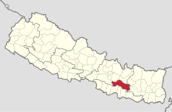
 Lage des Distriktes Sindhuli (rot) in Nepal | |
| Basisdaten | |
| Staat | Nepal |
| Provinz | Bagmati |
| Sitz | Kamalamai |
| Fläche | 2491 km² |
| Einwohner | 296.192 (Volkszählung 2011) |
| Dichte | 119 Einwohner pro km² |
| ISO 3166-2 | NP-P3 |
 | |
Koordinaten: 27° 15′ N, 85° 58′ O
Der Distrikt Sindhuli (Nepali सिन्धुली जिल्ला) ist ein Distrikt in Nepal.
Der Distrikt Sindhuli gehört seit 2015 zur Provinz Bagmati. Zuvor war es Teil der Verwaltungszone Janakpur in der Entwicklungsregion Mitte. Im Jahre 2001 hatte der Distrikt 279.821 Einwohner; 2011 waren es 296.192.[1][2]
Verwaltungsgliederung
Städte im Distrikt Sindhuli:
Village Development Committees (VDCs) im Distrikt Sindhuli:
- Amale
- Arun Thakur
- Bahuntilpung
- Balajor
- Baseshwar
- Bastipur
- Belghari
- Bhadrakali
- Bhiman
- Bhimeshwar
- Bhimsthan
- Bhuwaneshor Gwaltar
- Bitijor Bagaincha
- Dadiguranshe
- Dudbhanjyang
- Hariharpur Gadhi
- Harsahi
- Hatpate
- Jalkanya
- Jarayotar
- Jhangajholi Ratmata
- Jinakhu
- Kakur Thakur
- Kalpabrishykha
- Kapilakot
- Khang Sang
- Kholagaun
- Kuseswor Dumja
- Kyaneshwar
- Lampantar
- Mahadevdada
- Mahadevsthan
- Mahendrajhayadi
- Majuwa
- Netrakali
- Nipane
- Purano Jhangajholi
- Ranibas
- Ranichauri
- Ratamata
- Ratnachura
- Ratnawati
- Santeswari
- Siddheswari
- Sirthouli
- Sitalpati
- Solpathana
- Sunam Pokhari
- Tamajor
- Tinkanya
- Tosramkhola
- Tribhuvan Ambote
Weblinks
Commons: Distrikt Sindhuli – Sammlung von Bildern, Videos und Audiodateien
Einzelnachweise
- ↑ General Bureau of Statistics, Kathmandu, Nepal, Nov. 2012
- ↑ Central Bureau of Statistics, Census 2011: National Report (S. 51–52, Population Total und Area in Sq. Km). ( vom 18. April 2013 im Internet Archive) (PDF; 7,8 MB)
