
Datei:Map CZ - district Mlada Boleslav.PNG

Größe dieser Vorschau: 800 × 548 Pixel. Weitere Auflösungen: 320 × 219 Pixel | 640 × 439 Pixel | 1.024 × 702 Pixel | 1.281 × 878 Pixel
Originaldatei (1.281 × 878 Pixel, Dateigröße: 37 KB, MIME-Typ: image/png)
![]()
Diese Datei und die Informationen unter dem roten Trennstrich werden aus dem zentralen Medienarchiv Wikimedia Commons eingebunden.
![]()
Beschreibung
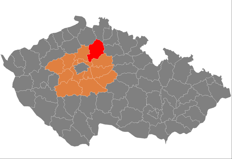
| Beschreibung | Location of Mladá Boleslav District in Central Bohemian Region and the Czech Republic. |
| Datum | Unbekanntes Datum |
| Quelle | self-made, based on Image:Czech_Republic_districts.png |
| Urheber | Michiel1972 |
Lizenz
| Ich, der Urheberrechtsinhaber dieses Werkes, veröffentliche es als gemeinfrei. Dies gilt weltweit. In manchen Staaten könnte dies rechtlich nicht möglich sein. Sofern dies der Fall ist: Ich gewähre jedem das bedingungslose Recht, dieses Werk für jedweden Zweck zu nutzen, es sei denn, Bedingungen sind gesetzlich erforderlich. |
Dateiversionen
Klicke auf einen Zeitpunkt, um diese Version zu laden.
| Version vom | Vorschaubild | Maße | Benutzer | Kommentar | |
|---|---|---|---|---|---|
| aktuell | 09:59, 5. Okt. 2007 | | 1.281 × 878 (37 KB) | Michiel1972 | {{Information |Description=Locator_maps_of_districts_of_the_Czech_Republic. |Source=self-made, based on Image:Czech_Republic_districts.png |Date= |Author= Michiel1972 }} [[category:Locator_maps_of_districts_of_the_Czech_Republic |
Dateiverwendung
Die folgende Seite verwendet diese Datei:
Globale Dateiverwendung
Die nachfolgenden anderen Wikis verwenden diese Datei:
- Verwendung auf azb.wikipedia.org
- Verwendung auf bg.wikipedia.org
- Verwendung auf en.wikipedia.org
- Verwendung auf eo.wikipedia.org
- Verwendung auf es.wikipedia.org
- Verwendung auf fa.wikipedia.org
- Verwendung auf fr.wikipedia.org
- Verwendung auf hu.wikipedia.org
- Verwendung auf it.wikipedia.org
- Verwendung auf ka.wikipedia.org
- Verwendung auf ms.wikipedia.org
- Verwendung auf nl.wikipedia.org
- Verwendung auf pnb.wikipedia.org
- Verwendung auf pt.wikipedia.org
- Mladá Boleslav
- Mnichovo Hradiště
- Benátky nad Jizerou
- Plazy
- Predefinição:Distrito de Mladá Boleslav
- Bezno
- Brodce
- Březno (Boêmia Central)
- Chotětov
- Sovínky
- Bílá Hlína
- Bítouchov
- Boreč
- Boseň
- Bradlec
- Branžež
- Březina (Boêmia Central)
- Březovice
- Bukovno
- Charvatce
- Chocnějovice
- Chudíř
- Ctiměřice
- Čachovice
- Čistá (Mladá Boleslav)
- Dalovice (Boêmia Central)
- Dlouhá Lhota (Mladá Boleslav)
- Dobšín
- Dolní Krupá (Boêmia Central)
- Dolní Slivno
- Dolní Stakory
- Domousnice
- Doubravička
- Horky nad Jizerou
- Horní Bukovina
- Horní Slivno
- Hrdlořezy
Weitere globale Verwendungen dieser Datei anschauen.