Yekyi
Yekyi ရေကြည်မြို့ | |
|---|---|
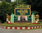
 Entrance sign of Yekyi | |
| Coordinates: 17°20′29″N 95°06′31″E / 17.3414°N 95.1087°E | |
| Country | |
| State | |
| District | Kyonpyaw District |
| Township | Yekyi Township |
| Area | |
• Total | 1.50 sq mi (3.9 km2) |
| Elevation | 19 ft (5.8 m) |
| Population (2023)[1] | 11,263 |
| Time zone | UTC+6.30 (MMT) |
Yekyi (Burmese: ရေကြည်မြို့) is a town in the north-central Ayeyarwady Region,south-west Myanmar.[2] It is the seat of the Yekyi Township in the Kyonpyaw District and is divided into 5 wards. The town sits on the southern bank of the Shwegu creek and curves with the meander of the creek.[3]
Yekyi is on the Pathein-Monywa highway connecting towns west of the Irrawaddy River in the lowlying central Burmese basin. This location provides easy access for produce and goods to travel in and out of the town.[3] However, according to a 2019 study, Yekyi was the least travelled destination for travellers from Pathein likely because the town only has one bus stop.[4]
References
- ^ General Administration Department (March 2023). Yegyi Myone Daethasaingyarachatlatmya ရေကြည်မြို့နယ် ဒေသဆိုင်ရာအချက်လက်များ [Township Regional Information] (PDF) (Report). Retrieved 22 December 2024.
- ^ IANS (2023-05-16). "5 killed after cyclone Mocha hits Myanmar". The Statesman. Retrieved 2023-05-17.
- ^ a b Myanmar Information Management Unit (September 2019). Yegyi Myone Daethasaingyarachatlatmya ရေကြည်မြို့နယ် ဒေသဆိုင်ရာအချက်လက်များ [Yegyi Township Regional Information] (PDF) (Report). MIMU. Retrieved December 19, 2024.
- ^ Nan Thazin Khine Oo; Kyaing; Ko Ko Lwin; Sekimoto, Yoshihide (2019). "Estimation of Intercity Travel Pattern and Impact on Yangon-Pathein Road between Ayeyarwady Region and Yangon Region Using Call Detail Record". Journal of the Eastern Asia Society for Transportation Studies. 13: 277–297. doi:10.11175/easts.13.277.


